Willkommen bei MapFox
Wurde Ihre Bestellung bestätigt? Wenn nicht - gab es evtl. ein SERVER-Problem! Bitte kontaktieren Sie uns! +++ Buchhändler-Anfragen erwünscht +++
Warenkorb
Artikel: 0 - € 0.00
Zur Kasse
Impressum Kontakt Versandkosten AGB
Frankreich: Wanderkarten Pyrenäen + Alpen + Bretagne - RANDO EDITION
<< Frankreich
 

Französisch-Spanische topografische Wanderkartenserie über die Pyrenäen und die Alpen im Maßstab 1:50.000. Die Höhenlinien liegen im 20 m-Abstand. Die markierten Wanderwege sind exakt eingezeichnet.
Die Legende liegt in französischer und spanischer Sprache vor (Pyrenäen-Karten), bzw. auf französisch und englisch (Alpen-Karten).

Westteil Ostteil

Blattschnitte der Alpen-Landkarten

Kartenbeispiel

Produkt EUR Anzahl Bestellen
CoverPyrenäen Frankreich / Spanien (Blatt 00) 1:400.000
Pirénées France / Espagne - Pirineos Espana / Francia Rando Edition Details...
Gelbes Karosymbol 15.90
Versandkostenfrei in Deutschland ab 30,- Bestellwert

incl. MwSt.
CoverA1 Pays du Mont-Blanc - Aravis - Chamonix - Courmayeur carte de randonnées 1:50.000 - (Alpes carte no. 1) Alpen-Wanderkarte RANDO EDITIONS Details...
Gelbes Karosymbol 17.90
Versandkostenfrei in Deutschland ab 30,- Bestellwert

incl. MwSt.
CoverA3 Vanoise - Tarentaise - Maurienne carte de randonnées 1:50.000 - (Alpes carte no. 3) Alpen-Wanderkarte RANDO EDITIONS Details...
Gelbes Karosymbol 17.90
Versandkostenfrei in Deutschland ab 30,- Bestellwert

incl. MwSt.
CoverA4 Massif des Bauges - Annecy - Chambéry carte de randonnées 1:50.000 - (Alpes carte no. 4) Alpen-Wanderkarte RANDO EDITIONS Details...
Gelbes Karosymbol 17.90
Versandkostenfrei in Deutschland ab 30,- Bestellwert

incl. MwSt.
CoverA5 Belledonne - Le Bourg-d`Oisans - Saint-Jean-de-Maurienne carte de randonnées 1:50.000 - (Alpes carte no. 5) Alpen-Wanderkarte RANDO EDITIONS Details...
Gelbes Karosymbol 17.90
Versandkostenfrei in Deutschland ab 30,- Bestellwert

incl. MwSt.
CoverA6 ECRINS - Bourg-d`Oisans - Briançon carte de randonnées 1:50.000 - (Alpes carte no. 6) Alpen-Wanderkarte RANDO EDITIONS Dieser Titel ist momentan nicht lieferbar. Details...
Rotes Karosymbol 17.90
Versandkostenfrei in Deutschland ab 30,- Bestellwert

incl. MwSt.
Cover1 Pays basque ouest - Labourd - Basse-Navarre carte de randonnées 1:50.000 (Pyrénées carte no. 1) - Pyrenäen-Wanderkarte RANDO EDITIONS Details...
Gelbes Karosymbol 17.90
Versandkostenfrei in Deutschland ab 30,- Bestellwert

incl. MwSt.
Cover2 Pays basque est Carte de randonnées 1:50.000 (Pyrénées carte no. 2) - Pyrenäen-Wanderkarte RANDO EDITIONS Details...
Grünes Karosymbol 17.90
Versandkostenfrei in Deutschland ab 30,- Bestellwert

incl. MwSt.
Cover3 Béarn - Aspe, Ossau, Parc National des Pyrénées carte de randonnées 1:50.000 (Pyrénées carte no. 3) - Pyrenäen-Wanderkarte RANDO EDITIONS Details...
Grünes Karosymbol 17.90
Versandkostenfrei in Deutschland ab 30,- Bestellwert

incl. MwSt.
Cover4 Bigorre - Cauterets - Gavarnie - St-Lary-Soulan - Parc National des Pyrénées carte de randonnées 1:50.000 (Pyrénées carte no. 4) - Pyrenäen-Wanderkarte RANDO EDITIONS Details...
Grünes Karosymbol 17.90
Versandkostenfrei in Deutschland ab 30,- Bestellwert

incl. MwSt.
Cover5 Luchon - Comminges - Louron carte de randonnées 1:50.000 (Pyrénées carte no. 5) - Pyrenäen-Wanderkarte RANDO EDITIONS Details...
Gelbes Karosymbol 17.90
Versandkostenfrei in Deutschland ab 30,- Bestellwert

incl. MwSt.
Cover6 Couserans - Valier - Maubermé carte de randonnées 1:50.000 (Pyrénées carte no. 6) - Pyrenäen-Wanderkarte RANDO EDITIONS Details...
Grünes Karosymbol 17.90
Versandkostenfrei in Deutschland ab 30,- Bestellwert

incl. MwSt.
Cover7 Haute-Ariège - Vicdessos - Orlu carte de randonnées 1:50.000 (Pyrénées carte no. 7) - Pyrenäen-Wanderkarte RANDO EDITIONS Details...
Grünes Karosymbol 17.90
Versandkostenfrei in Deutschland ab 30,- Bestellwert

incl. MwSt.
Cover8 Cerdagne - Capcir - Font-Romeu - Ax-les-Thermes carte de randonnées 1:50.000 (Pyrénées carte no. 8) - Pyrenäen-Wanderkarte RANDO EDITIONS Details...
Grünes Karosymbol 17.90
Versandkostenfrei in Deutschland ab 30,- Bestellwert

incl. MwSt.
Cover9 Sentier Cathare - Quéribus - Peyrepertuse - Puylaurens - Montségur carte de randonnées 1:55.000 (Pyrénées carte no. 9) - Pyrenäen-Wanderkarte RANDO EDITIONS Details...
Grünes Karosymbol 17.90
Versandkostenfrei in Deutschland ab 30,- Bestellwert

incl. MwSt.
Cover10 Canigou - Carrotxa carte de randonnées 1:50.000 (Pyrénées carte no. 10) - Pyrenäen-Wanderkarte RANDO EDITIONS Details...
Grünes Karosymbol 17.90
Versandkostenfrei in Deutschland ab 30,- Bestellwert

incl. MwSt.
Cover11 Collioure-Cadaqués - Massif des Albères - Côte Vermeille - Cap de Creus carte de randonnées 1:50.000 (Pyrénées carte no. 11) - Pyrenäen-Wanderkarte RANDO EDITIONS Details...
Grünes Karosymbol 17.90
Versandkostenfrei in Deutschland ab 30,- Bestellwert

incl. MwSt.
Cover
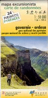
12 Gavarnie - Ordesa carte de randonnées 1:50.000 (Pyrénées carte no. 11) - Pyrenäen-Wanderkarte RANDO EDITIONS
Pyréenées Gavarnie/Ordesa - 1/50 000 Details...
Grünes Karosymbol 17.90
Versandkostenfrei in Deutschland ab 30,- Bestellwert

incl. MwSt.
Cover13 Aneto-Posets - Bachimala - Cotiella - Turbon carte de randonnées 1:50.000 (Pyrénées carte no. 13) - Pyrenäen-Wanderkarte RANDO EDITIONS
13 Pyréenées Aneto-Posets Details...
Grünes Karosymbol 17.90
Versandkostenfrei in Deutschland ab 30,- Bestellwert

incl. MwSt.
Cover14 Sierra de Guara - Parque Natural de la Sierra y Cañones de Guara Pyrenäen-Wanderkarte 1:50.000
14 Pyréenées Sierra de Guara - carte de randonnées RANDO EDITIONS Spanien Details...
Gelbes Karosymbol 17.90
Versandkostenfrei in Deutschland ab 30,- Bestellwert

incl. MwSt.
Cover21 Andorra - Cadí (Parc Natural del Cadí-Moixeró) - mapa excursionista 1:50.000 (Pirineos) - Pyrenäen-Wanderkarte RANDO EDITIONS Dieser Titel ist momentan nicht lieferbar. Details...
Rotes Karosymbol 17.90
Versandkostenfrei in Deutschland ab 30,- Bestellwert

incl. MwSt.
Cover25 Ansó - Hecho (Orhy - Roncal - Anie - Bisaurín) - mapa excursionista 1:50.000 (Pirineos) - Pyrenäen-Wanderkarte RANDO EDITIONS Dieser Titel ist momentan nicht lieferbar. Details...
Rotes Karosymbol 17.90
Versandkostenfrei in Deutschland ab 30,- Bestellwert

incl. MwSt.
CoverL2 Ré - Oléron 1:50.000 GPS La Rochelle - Rochefort - Charente-Maritime Wanderkarte RANDO EDITIONS
Carte de randonnées (Carte L2) Details...
Gelbes Karosymbol 12.50
Versandkostenfrei in Deutschland ab 30,- Bestellwert

incl. MwSt.


Zuletzt angesehene Artikel:

CoverSlowenien - 30 Mountainbiketouren im Soca-Tal MTB-Führer von Peter Immich, Michael Vemmler - freiraus Verlag

CoverL5154 Zittau 1:50.000 Amtliche Topografische Landkarte - Landesvermessungsamt Sachsen

CoverPrato - Montemurlo Stadtplan 1:12.000
Prato - Montemurlo - Pianta della Citta L.A.C. GlobalMap Italien

CoverSchitomir Stadtplan 1:14.000
Zhytomyr Kartografija - ukrmap Ukraine

CoverPC4 Südwestliche Kykladen 1:163.000 Seekarte Griechenland - WGS84
PC4 Νοτιοδυτικές Κυκλάδες / Notiodytikes Kyklades / Southwestern Cyclades - Sea Chart - Pilot Chart Eagle Ray Griechenland

CoverFalk Stadtplan Extra Standardfaltung Nürnberg Mit Ortsteilen von Feucht, Fürth, Heroldsberg, Oberasbach, Röthenbach a. d. P., Schwaig, Stein, Zirndorf

CoverSliwen - Stadtplan 1:6.000
Sliven Domino - Bulgarien

CoverL7116 Karlsruhe Süd Topographische Landkarte 1:50.000 - Landesvermessungsamt Baden-Württemberg

CoverSF 525 Viena - Stadtführer KOMPASS

CoverPuzzle Kanada Souvenir LARSEN-Puzzle KH6 (66 Teile)

CoverMoselsteig - Entlang der Mosel von Perl nach Koblenz Wanderführer von Thorsten Lensing - Bergverlag Rother

CoverZadar - Stadtplan 1:10.000 / Umgebungskarte 1:150.000
Zadar - plan grada Forum Zadar

CoverSerbien: Klöster und Kirchen Touristische Landkarte 1:600.000
SERBIA Monasteries & Churches / Манастири и Цркве Србиjе Manastiri i Zrkwe Srbije Intersistem Serbien

CoverPaxos - Antipaxos (Blatt 305) Landkarte Griechische Inseln 1:25.000
Paxi / Antipaxi - Παξοί / Αντίπαξος Orama - Griechenland

Noch kein Cover vorhandenHemet / Perris / Sun City / Menifee+A162 Stadtplan 1:28.000 (Kalifornien - USA)
Hemet / Perris / Sun City / Menifee+A162 street map Global Graphics / GM Johnson

Noch kein Cover vorhandenN-34-115-C/D Pultusk Amtliche topographische Landkarte Polen 1:50.000
N-34-115-C/D Pultusk - Mapa Topograficzna Polski Glowny Geodeta Kraju

Noch kein Cover vorhandenN-34-85-A/B Osie Amtliche topographische Landkarte Polen 1:50.000
N-34-85-A/B Osie - Mapa Topograficzna Polski Glowny Geodeta Kraju

CoverShort Walks in Cornwall (englisch) - Wanderführer
Guide to 20 easy walks - Collins Ramblers

CoverNaturpark Südeifel Blatt 2 (Mitte) Neuerburg - Körperich - Vianden (S2) Topographische Wanderkarte 1:25.000 - Landesamt für Vermessung und Geobasisinformation Rheinland-Pfalz

CoverE02 Stadtprozelten - Freudenberg, Faulbach, Eschau, Heimbuchenthal, Mönchberg, Großheubach ATK25 Topographische Karte 1:25.000 (Atkis) Bayern Landesvermessungsamt Bayern - Wanderkarte