| << Schweden: Wegekarten - Lantmäteriets Vägkarta - Landkarten 1:100.000 |
  | |
|
||
Zuletzt angesehene Artikel:
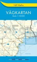
![]() | 169 Kalix - Vägkartan 1:100.000 Topographische Karte Schweden - Lantmäteriet Landkarte Schweden, Straßenkarte |
![]() | 1032 DIESSENHOFEN 1:25.000 - Feuerthalen - Thayngen - Stein a. Rh. - Topographische Landeskarte der Schweiz - swisstopo |
![]() | 1835SB Saint-Astier - Mussidan GPS Amtliche Topographische Wanderkarte Frankreich 1:25.000 - série bleue (IGN) |
![]() | 1344SB Peyrehorade - Hasparren GPS Amtliche Topographische Wanderkarte Frankreich 1:25.000 - série bleue (IGN) |
![]() | 1412OT POINTE DU HOC/OMAHA-BEACH Topographische Wanderkarte Frankreich 1:25.000 TOP 25 IGN - (GPS) |
![]() | Versilia - Reviera Apuana - Alpi Apuane - Topographische Wanderkarte 1:50.000 (Blatt 711) Carta Turistica e dei Sentieri - Edizioni Multigraphic - Italien |
![]() | Australien + Städte - Straßenkarte 1:4.5 Mio. Country Map Australia + cities HEMA maps Australien |
![]() | 1735SB Montpon-Ménestérol - St-Médard-de-Mussidan GPS Amtliche Topographische Wanderkarte Frankreich 1:25.000 - série bleue (IGN) Montpon-Ménéstrol - Saint-Medard-de-Mussidan |
![]() | 5704 Prüm Topographische Karte 1:25.000 - Landesamt für Vermessung und Geobasisinformation Rheinland-Pfalz |
![]() | 1642SB Villeneuve-de-Marsan - Nogaro GPS Amtliche Topographische Wanderkarte Frankreich 1:25.000 - série bleue (IGN) |
![]() | M-34-79-C/D Jaslo Amtliche topographische Landkarte Polen 1:50.000 M-34-79-C/D Jaslo - Mapa Topograficzna Polski Glowny Geodeta Kraju |
![]() | 2444 Penzlin Amtliche Topographische Karte 1:25.000 Landesvermessungsamt Mecklenburg-Vorpommern |
![]() | 2349ET MASSIF-DU-CANIGOU Topographische Wanderkarte Frankreich 1:25.000 TOP 25 IGN - (GPS) |
![]() | Malerweg Elbsandsteingebirge Leporello Wanderkarte mit Ausflugszielen, Einkehr- & Freizeittipps, wetterfest, reissfest, abwischbar, GPS-genau. 1:25000 - von - Freytag-Berndt und ARTARIA Publicpress |
![]() | 12-12 Topographische Karte 1:50.000 der Tschechischen Republik Zakladnà mapa Ceská republika - Cesky urad zememericky a katastralni - ProjektNord |
![]() | Rauhelleren Wanderkarte Norwegen 1:50.000 (Blatt 2727) - Nordeca / UGLAND / Statens Kartverk Norwegen |
![]() | Coppo dell`Orso 1:25.000 (CO) Wanderkarte S.EL.CA - Club Alpino Italiano (CAI) - Italien (SELCA) |
![]() | 14-143 Topographische Karte 1:25.000 der Tschechischen Republik Zakladnà mapa Ceská republika Cesky urad zememericky a katastralni - ProjektNord |
![]() | Moskau - St. Petersburg Nelles-Reiseführer Nelles-Verlag |
![]() | 46 VAL DE BAGNES 1:100.000 - Mont Blanc - Martigny - Aosta/Aoste - Evolène - Topographische Landeskarte der Schweiz - swisstopo |


