| << Cookinseln - Tokelau-Inseln - Niue - Kermadecinseln |
||
|
||
Zuletzt angesehene Artikel:
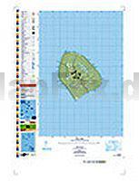
 | PI15 Atiu (Cookinseln) Topographische Landkarte 1:25.000 - Land Information New Zealand |
 | Dinarisches Gebirge 2 - Naturpark Dinara - Troglav mit Wanderwegen und Radwegen - Wanderkarte - Fahrradkarte 1:30.000 Kroatien - Bosnien-Herzegowina - ProjektNord |
 | 3136ET COMBE-LAVAL/FORET DE LENTE Topographische Wanderkarte Frankreich 1:25.000 TOP 25 IGN - (GPS) |
 | 12 Mellersta Gotland 1:50.000 (wasserfest) Topographische Wanderkarte - Sverigeserien Topo50 - Schweden Kartförlaget |
 | 2: Sierra de Ramón Trekkingkarte - Andes-handbook - Chile |
 | Languedoc-Roussillon Regionale Straßenkarte 1:200.000 (Blatt 526) Michelin Frankreich |
 | EV00 VÄTTERN-SOMMENSERIEN Topographische Wanderkarten 1:50.000 - Kartenserie VÄTTERN-SOMMENSERIEN - Kartserie, Terrängkarta UTEKARTAN - Schweden |
 | 16 Fünf Gebirge aus dem Karpatenbogen - Königstein - Bucegi - Schuller - Großstein - Tschukasch Wanderkarte Rumänien 1:70.000 Cinci munti din Carbura Carpatilor - Piatra Craiului - Bucegi - Postavarul - Piatra Mare - Ciucas Dimap |
 | 37 Valle di Champorcher - Parco Mont Avic - Valle Centrale 1:25.000 (wasserfest) Topographische Wanderkarte und Straßenkarte 1:25.000 Fraternali Editore - Italien |
 | El Turbon - Alto Valle de Isabena 1:25.000 Wanderkarte Spanien - ALPINA El Turbón - Alto Valle de Isábena |
 | Piemont - Aostatal 1:200.000 Straßenkarte Italien (Blatt 351) Piemonte - Valle d`Aosta Michelin Local |
 | Moselberge - Schweich - Mehring Topographische Wanderkarte Rheinland-Pfalz mit Wanderwegen und Radwegen 1:25.000 - ProjektNord |
 | Pucon 1:100.000 Trekkingkarte Pucón Trekking Map Viachile Editores - Chile |
 | 170 Abingdon - Wantage & Vale of White Horse - Wanderkarte Großbritannien 1:25.000 EXPLORER MAP - Ordnance Survey |
 | 242T AVENCHES - Fribourg - Morat - Neuchatel 1:50.000 Topographische Wanderkarte SAW der Schweiz - swisstopo |
 | Rhônetal - Französische Alpen Regionale Straßenkarte 1:200.000 (Blatt 523) Michelin Frankreich |
 | 43 Strömstad 1:50.000 (wasserfest) Topographische Wanderkarte - Sverigeserien Topo50 - Schweden Kartförlaget |
 | 24 Pilgrams - Böhmisch Kanada - Touristische Landkarte Tschechien 1:100.000 Pelhrimovsko - Ceská Kanada - Turistická mapa KARTOGRAFIE PRAHA |
 | 41 COL DU PILLON 1:100.000 Topographische Landeskarte der Schweiz - swisstopo |
 | GR512 Brabantse Heuvelroute - Diest - Geraardsbergen 173km Wanderführer (flämisch) Brabantse Heuvelroute GR512 - Van Diest naar Geraardsbergen 173km GROTE ROUTEPADEN |