Willkommen bei MapFox
Wurde Ihre Bestellung bestätigt? Wenn nicht - gab es evtl. ein SERVER-Problem! Bitte kontaktieren Sie uns! +++ Buchhändler-Anfragen erwünscht +++
Warenkorb
Artikel: 0 - € 0.00
Zur Kasse
Impressum Kontakt Versandkosten AGB
42C OOSTKAPELLE Topographische Karte der Niederlande 1:25.000 (Plotausgabe)
42C OOSTKAPELLE Topografische Kaart van Nederland Kadaster - ProjektNord
<< Niederlande: Amtliche Topographische Landkarte 1:25.000
 
Cover

Hochwertige topographische Karte der Niederlande.

Blattschnitte

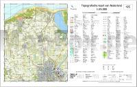
Kartenbeispiel aus der Serie

Wir liefern bei Bedarf alle Blätter der Serie. HINWEIS: Dieses Blatt haben wir zugunsten von mehr Landfläche (und weniger Wasser) etwas nach Süden verschoben. Es reicht nun bis Middelburg. Es geht keine Landfläche verloren!

Hinweis: Diese Karte wird individuell auf Kundenbestellung gedruckt und ist daher von der Rückgabe ausgeschlossen.

Kartenausschnitt

42C OOSTKAPELLE Topographische Karte der Niederlande 1:25.000 (Plotausgabe)
42C OOSTKAPELLE Topografische Kaart van Nederland Kadaster - ProjektNord
Preis: EUR 19.90

sofort versandfertig Dieser Artikel ist im Normalfall sofort lieferbar.
Produkt EUR Anzahl Bestellen
42C OOSTKAPELLE Topographische Karte der Niederlande 1:25.000 (Plotausgabe)
42C OOSTKAPELLE Topografische Kaart van Nederland Kadaster - ProjektNord
19.90
Versandkostenfrei in Deutschland ab 30,- Bestellwert

incl. MwSt.

Stichworte, die bei der Suche nützlich sein könnten:
Niederlande Topographische Karte - Landkarte Niederlande - Niederlande - Niederlande Amtliche Karten - Topografische Dienst Nederland - Niederlande Topographische Landkarte - Niederlande Topographische Karten - Niederlande Landkarten - Niederländische Topos

Zuletzt angesehene Artikel:

Cover42C OOSTKAPELLE Topographische Karte der Niederlande 1:25.000 (Plotausgabe)
42C OOSTKAPELLE Topografische Kaart van Nederland Kadaster - ProjektNord

Cover38D SLIEDRECHT Topographische Karte der Niederlande 1:25.000 (Plotausgabe)
38D SLIEDRECHT Topografische Kaart van Nederland Kadaster - ProjektNord

Cover24 Skeidararsandur Atlaskort - Topographische Landkarte Island 1:100.000
Skeiðarársandur Forlagid - Mál og menning - Island

Cover55A HULST Topographische Karte der Niederlande 1:25.000 (Plotausgabe)
55A HULST Topografische Kaart van Nederland Kadaster - ProjektNord

Cover19H EDAM Topographische Karte der Niederlande 1:25.000 (Plotausgabe)
19H EDAM Topografische Kaart van Nederland Kadaster - ProjektNord

Cover25D AMSTELVEEN Topographische Karte der Niederlande 1:25.000 (Plotausgabe)
25D AMSTELVEEN Topografische Kaart van Nederland Kadaster - ProjektNord

Cover10H SNEEK Topographische Karte der Niederlande 1:25.000 (Plotausgabe)
10H SNEEK Topografische Kaart van Nederland Kadaster - ProjektNord

Cover43F STRIJEN Topographische Karte der Niederlande 1:25.000 (Plotausgabe)
43F STRIJEN Topografische Kaart van Nederland Kadaster - ProjektNord

Cover48E HEINKENSZAND Topographische Karte der Niederlande 1:25.000 (Plotausgabe)
48E HEINKENSZAND Topografische Kaart van Nederland Kadaster - ProjektNord

Cover16B WOLVEGA Topographische Karte der Niederlande 1:25.000 (Plotausgabe)
16B WOLVEGA Topografische Kaart van Nederland Kadaster - ProjektNord

Cover40E DOESBURG Topographische Karte der Niederlande 1:25.000 (Plotausgabe)
40E DOESBURG Topografische Kaart van Nederland Kadaster - ProjektNord

Cover43G DINTELOORD Topographische Karte der Niederlande 1:25.000 (Plotausgabe)
43G DINTELOORD Topografische Kaart van Nederland Kadaster - ProjektNord

Cover52H VENLO Topographische Karte der Niederlande 1:25.000 (Plotausgabe)
52H VENLO Topografische Kaart van Nederland Kadaster - ProjektNord

Cover20B HOUTRIBDIJK Topographische Karte der Niederlande 1:25.000 (Plotausgabe)
20B HOUTRIBDIJK Topografische Kaart van Nederland Kadaster - ProjektNord

Cover60E VLODROP Topographische Karte der Niederlande 1:25.000 (Plotausgabe)
60E VLODROP Topografische Kaart van Nederland Kadaster - ProjektNord

Cover39H BERGHAREN Topographische Karte der Niederlande 1:25.000 (Plotausgabe)
39H BERGHAREN Topografische Kaart van Nederland Kadaster - ProjektNord

CoverMarmolada - Pelmo - Civetta - Nuvolau Wanderkarte und Mountainbike-Karte 1:25.000 (Blatt 10)
Carta Escursionistica e Mountainbike Casa Editrice Lagiralpina - Italien

Cover09E DE COCKSDORP Topographische Karte der Niederlande 1:25.000 (Plotausgabe)
09E DE COCKSDORP Topografische Kaart van Nederland Kadaster - ProjektNord

Cover49E WOUW Topographische Karte der Niederlande 1:25.000 (Plotausgabe)
49E WOUW Topografische Kaart van Nederland Kadaster - ProjektNord

Cover26E LARSERBOS Topographische Karte der Niederlande 1:25.000 (Plotausgabe)
26E LARSERBOS Topografische Kaart van Nederland Kadaster - ProjektNord