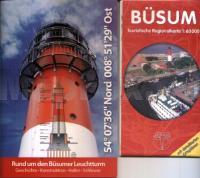
| << Schleswig-Holstein: Nordfriesische Inseln und Nordseeküste << Kartenwerk |
  | |
Zuletzt angesehene Artikel:
![]() | Büsum Touristische Regionalkarte 1:60.000 + Broschüre ´Rund um den Büsumer Leuchtturm´ im Set - Verlag Kartenwerk |
![]() | 045 Val Martello - Silandro - Laces / Martelltal - Schlanders - Latsch Topographische Wanderkarte 1:25.000 - Casa Editrice Tabacco - Italien |
![]() | M-34-106-C/D Nyzhnya Yablunka Amtliche topographische Landkarte Polen 1:50.000 M-34-106-C/D Nyzhnya Yablunka - Mapa Topograficzna Polski Glowny Geodeta Kraju |
![]() | 8024 Bad Waldsee Topographische Landkarte 1:25.000 - Landesvermessungsamt Baden-Württemberg |
![]() | 4721SB Montagne des Trois Pitons - Topographische Wanderkarte Französisch Guayana 1:25.000 TOP 25 - (GPS) Regina IGN Frankreich |
![]() | Dammer Berge Topographische Wanderkarte mit Wanderwegen und Radwegen 1:25.000 Niedersachsen - ProjektNord |
![]() | M-34-71-C/D Lubaczow Amtliche topographische Landkarte Polen 1:50.000 M-34-71-C/D Lubaczow - Mapa Topograficzna Polski Glowny Geodeta Kraju |
![]() | 3337 Stendal Topographische Karte 1:25.000 Landesamt für Vermessung und Geoinformation Sachsen-Anhalt (Landesvermessungsamt) |
![]() | 2927SB ST-GENGOUX-LE-NATIONAL - ST-BONNET-DE-JOUX GPS Amtliche Topographische Wanderkarte Frankreich 1:25.000 - série bleue (IGN) |
![]() | Saint Lucia (Karibik) 1:45.000 - Landkarte - Road map with Place Index, Hiking Trails and Diving Sites St. Lucia (Caribbean) GMP - Geographic Map Publishing - midok - Michal Kasprowsky |
![]() | Insel Korcula (West und Ost) 1:25.000 (Blatt 11) Bergwanderkarte und Bergsteigerkarte - Serija Dinarske Alpe Korčula / Korčula Island (East & West) - Serija Dinarske Alpe - Mountaineering and Hiking map - Croatian Mountain Rescue Service Kroatischer Bergrettungsdienst - Kroatien |
![]() | Indre-et-Loire - Maine-et-Loire Straßenkarte 1:150.000 Frankreich (Blatt 317) Michelin Départements |
![]() | 4433 Wippra Topographische Karte 1:25.000 Landesamt für Vermessung und Geoinformation Sachsen-Anhalt (Landesvermessungsamt) |
![]() | Vallorbe - Pontarlier - Ste-Croix - Le Sentier (Blatt 30) 1:50.000 Topographische Skitourenkarte der Schweiz - SNOW TRAIL MAP |
![]() | Guadarrama - Parc Natural de Penalara (engl.) E25 1:25.000 Wanderkarte Spanien - ALPINA |
![]() | Flensburg - Holnis Topographische Wanderkarte mit Wanderwegen und Radwegen 1:25.000 Schleswig-Holstein - ProjektNord |
![]() | 3011SB VOUZIERS - GRANDPRE GPS Amtliche Topographische Wanderkarte Frankreich 1:25.000 - série bleue (IGN) |
![]() | MORBIHAN (Blatt D56) Département-Landkarte Frankreich 1:100.000 MORBIHAN - Carte départementale - IGN Frankreich |
![]() | 0714OT LANNION / PERROS-GUIREC - Les Sept Iles - Cote de Granit Rose Topographische Wanderkarte Frankreich 1:25.000 TOP 25 IGN - (GPS) |
![]() | Baja California North - GPS 1:450.000 (Blatt 3103) Landkarte - Adventure Map (Blatt 3103) - National Geographic - Mexiko |


