Willkommen bei MapFox
Wurde Ihre Bestellung bestätigt? Wenn nicht - gab es evtl. ein SERVER-Problem! Bitte kontaktieren Sie uns! +++ Buchhändler-Anfragen erwünscht +++
Warenkorb
Artikel: 0 - € 0.00
Zur Kasse
Widerruf Impressum Kontakt Versandkosten AGB
2786 04 Mount Everest - Sagarmatha (16) 1:50.000 Island Peak, Lobuje, Pokalde, Kongma Tse, Tyanboche FINN MAPS - HMG Nepal
<< Nepal: Amtliche Topographische Karten 1:50.000 (Finn-Maps)
 
Cover

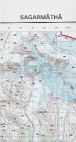
· Sheet covering Everest from the official topographic survey of Nepal
· Other peaks shown include Lhotse, Nuptse, Ama Dablam, and Island Peak
· Detailed full-colour topographic mapping
· Roads, footpaths and hiking trails clearly marked
· Contours at 40 m vertical intervals with spot heights for peaks and passes
· Land-use colouring and annotations
· Both major and minor trails shown
· Note that the Tibetan side of the border is left blank

Kartenausschnitt

Kartenbeispiel

2786 04 Mount Everest - Sagarmatha (16) 1:50.000 Island Peak, Lobuje, Pokalde, Kongma Tse, Tyanboche FINN MAPS - HMG Nepal
Preis: EUR 15.90

Bestellartikel: versandfertig in ca. 1-3 Wochen. Dieser Artikel wird speziell für Sie bestellt. Keine Rücknahme!
Produkt EUR Anzahl Bestellen
2786 04 Mount Everest - Sagarmatha (16) 1:50.000 Island Peak, Lobuje, Pokalde, Kongma Tse, Tyanboche FINN MAPS - HMG Nepal 15.90
Versandkostenfrei in Deutschland ab 30,- Bestellwert

incl. MwSt.

Stichworte, die bei der Suche nützlich sein könnten:
Nuptse - Mount Everest - Khumbu-Gletscher - Island Peak - Ama Dablam - Mt. Everest - Lhotse - Everest Base Camp - Himalaya - Nepal Trekkingkarten - Nepal Wanderkarten - Nepal Topographische Karten - Nepal Amtliche Landkarten

Zuletzt angesehene Artikel:

Cover2786 04 Mount Everest - Sagarmatha (16) 1:50.000 Island Peak, Lobuje, Pokalde, Kongma Tse, Tyanboche FINN MAPS - HMG Nepal

CoverRomsdalsfjorden - Molde - Åndalsnes - Seekarte Norwegische Küste 1:50.000 - (Blatt 34) Den Norske Kyst
Sjøkart - Hovedkart (sjø) Statens Kartverk Sjø - Norwegen

CoverParco Nazionale dello Stelvio - Carta 1 - Bormio - Livigno - Val di Fraele - Laghi di Cancano - Topographische Wanderkarte 1:25.000 Ingenia Editori - Italien

Noch kein Cover vorhanden325 Slettnes - Grense Jakobselv Norwegen Küstenkarte 1:200.000
325 Kystkart Statens Kartverk Sjø - Norwegen

CoverNorwegen - Straßenkarte Südnorwegen Süd 1:500.000
Veikart Sør-Norge Sør Nordeca / UglandIT / Statens Kartverk - Norwegen

Cover51 Jastrebarsko - Topographische Landkarte Slowenien 1:50.000 - Amtliche Kartengrundlage ProjektNord