Willkommen bei MapFox
+++ Buchhändleranfragen willkommen! Tel. 0431-666 75 99 +++
Warenkorb
Artikel: 0
€ 0.00

Zur Kasse
Impressum Kontakt Versandkosten AGB Partnerprogramm Links
Aktuelle Infos

Erweitertes Sortiment

Stöbern

Europa-Übersichtskarte


NEU im Sortiment
Geschenkgutscheine
Individuelle Landkarten
Poster, Wandkarten, Reliefkarten
Globen
Landkarten-Puzzles
Europa - allgemein
Welt - allgemein
Außereuropäische Länder
Albanien
Andorra
Baltikum
Bosnien-Herzegowina
Bulgarien
Belgien
Benelux
Dänemark
Deutschland
Estland
Finnland
Frankreich
Griechenland
Großbritannien
Irland
Island
Italien
Kosovo
Kroatien
Lettland
Liechtenstein
Litauen
Luxemburg
Malta
Mittelmeer und Mittelmeer-Inseln
Moldawien
Montenegro
Niederlande
Nordmazedonien
Norwegen
Österreich
Polen
Portugal
Rumänien
Russland
Schweden
Schweiz
Serbien
Skandinavien
Slowakei
Slowenien
Spanien
Tschechien
Türkei
Ukraine
Ungarn
Weißrussland (Belarus)
Zypern
Verlage
Digitale Landkarten auf CD-ROM / DVD, SD-Karte
Reisen allgemein
Astronomische Karten und Bücher
NonBooks und Zubehör
Schnäppchen - Restposten - Mängelexemplare
Top-Destinationen
Extra-Sortiment
Wanderwege - Routen - Fernradwege
Literatur über Landkarten, Vermessung, Entdeckungen
Historische Landkarten

Schnäppchen

Gesamtübersicht

Startseite

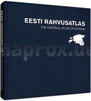
The National Atlas of Estonia
EESTI RAHVUSATLAS Taavi Pae (University of Tartu) - Department of Geography / Map Publisher REGIO Estland
<< Estland
<< Regio Ltd. Estland
 

Language: Estonian and English
Hardcover: 424 pages
Dimensions: 30 x 30 cm

The atlas contains nearly 500 historical and contemporary maps along with fascinating explanations that help to give meaning to Estonian nature, culture and history. The maps are grouped into 36 topical chapters that describe the formation of Estonia`s borders, the Estonian climate, forestry, healthcare and population, among other topics. The Estonian language, the origin of Estonians, folklore, education and religion are also examined.

The atlas opens with a map of Estonia featuring the signature of General Johan Laidoner that recalls the birth of the Republic of Estonia and that was used to show the world the location and borders of the young republic in 1920. In addition to more serious topical maps, you can also find maps about the spread of kama (mixed grains) and blood sausages in Estonia, a map of the birthplaces of the Estonian elite created in 1938 and a map with the locations of communal saunas from 1967.

The Estonian national atlas was born in cooperation with geographers from the University of Tartu and map makers from Regio. For historical maps, however, we are grateful to our predecessors from earlier centuries.

Introducing exciting and diverse Estonian cartography, this work is a great guide to the wonderful world of maps.

The National Atlas of Estonia is dedicated to the 100th anniversary of the Estonia’s National University and of Estonian-language geography.

Kartenbeispiel

The National Atlas of Estonia
EESTI RAHVUSATLAS Taavi Pae (University of Tartu) - Department of Geography / Map Publisher REGIO Estland
EAN / ISBN: 9789949599622
Preis: EUR 169.00

Bestellartikel: versandfertig in ca. 2 Wochen oder länger. Dieser Artikel wird speziell für Sie bestellt. Keine Rücknahme!
Produkt EUR Anzahl Bestellen
The National Atlas of Estonia
EESTI RAHVUSATLAS Taavi Pae (University of Tartu) - Department of Geography / Map Publisher REGIO Estland
169.00
Versandkostenfrei in Deutschland

incl. MwSt.

Stichworte, die bei der Suche nützlich sein könnten:
Eesti Rahvusatlas - Estonia Atlas - Estland Atlas - Estland - Eesti - Estonia - Estland Straßenkarten - Estland Autokarten - Estland Fahrradkarten - Estland Autoatlanten - Estland Straßenatlanten - Landkarten aus Estland - Estland Landkarten - Estonia maps - Estland Reiseführer - Estlandkarten - estnische Landkarten - Estonian maps - Estland Karten - Regio Ltd. - Regi Verlag Estland - Estland - Estonia - Eesti - Estland Landkarten - Estonia maps - Eesti - Estnische Lankarten


Startseite  Gesamtübersicht  Allg. Geschäftsbed.  Impressum Aktuelle Infos
  • Aktuelle Karten - Historische Namen
    zweisprachige Landkarten über Polen und das Kaliningrader Gebiet

  • Thüringer Wald
    Das klassische Wandergebiet im Herzen Deutschlands

  • Jakobsweg
    Karten und Reiseführer zum Pilgern


    Estland-Atlas
    Estland komplett - ein wertvoller Atlas!


    Hinweis für Kunden aus der Schweiz ...

    Bei Zahlung auf unser Postfinance-Konto fallen keine Auslandsspesen an.


    Der Kartenfux zum Verschenken
    Jetzt Urlaubs-Vorfreude schenken mit einem Mapfox-Gutschein


    Die Topographische Karte von Irgendwo?
    ... gibt´s hier. Weltweit.


    Dieser Sitzball ...
    ... ist ein detaillierter Globus


    Die Welt ist ein Geschenkpapier


    Deutschland in 1000 Teilen
    ... unser schönstes Panorama-Puzzle


    Magnetpuzzle WELT


    Vianina Stadtplan-Poster


    Landkarten-Puzzles
    Wunderschöne Geschenkidee für helle Köpfchen ab 5 J.


    Schicke Taschen


    Foxxi der Kuschelfuchs
    Der MapFox-Fuchs jetzt auch zum Kuscheln!


    Historische Landkarten


    Schreibtisch-Unterlagen
    So prägt sich die Deutschlandkarte ein!


    Die Welt aus dem All
    Dekorative Satellitenbild-Poster in gestochen scharfer Auflösung!