Willkommen bei MapFox
Wurde Ihre Bestellung bestätigt? Wenn nicht - gab es evtl. ein SERVER-Problem! Bitte kontaktieren Sie uns! +++ Buchhändler-Anfragen erwünscht +++
Warenkorb
Artikel: 0 - € 0.00
Zur Kasse
Widerruf Impressum Kontakt Versandkosten AGB
Sunnmøre Alps - Ski-Reiseführer (englisch) - Fri Flyt AS
Skiguide for the mountains around Hjørundfjorden, Austefjorden og Storfjorden
<< Norwegen: Wanderführer - Radwanderführer - Reiseführer - Kletterführer
 
Cover

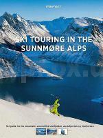
The Sunnmøre Alps is one of the most beautiful areas for ski touring in Norway. White-clad mountains plunge into the deep fjords, and from the mountain tops you can enjoy panoramas of alpine peaks and glaciers. Spend the evening by the coast and you can watch the sun sink down into the Atlantic. Stig J. Helset and Håvard Myklebust have produced a long-awaited guidebook for Ski Touring in the Sunnmøre Alps. For the first time, it is published in English. There is a special focus on the Hjørundfjorden area, and you will find tours to some of the most iconic alpine ski touring mountains in Norway, such as Skårasalen, Randers Topp and Slogen. There are also two suggested multi-day traverses around Hjørundfjorden. You will find overview images of the various mountain faces, with routes drawn directly onto the images. A special chapter about avalanches and cornice hazards is written by IFMGA mountain guide Christer Lundberg Nes. Stig J. Helset (46) has been climbing the peaks of the Sunnmøre Alps all year long, for all of his life. He is the author of the book and has made all the route drawings. He is an Associate Professor in Norwegian language at Volda University College. Håvard Myklebust (26) is one of Norway’s leading outdoor photographers, and has taken most of the pictures. He is also a top level skimo racer and works as an engineer. Translated by David Glass

Kartenbeispiel

Sunnmøre Alps - Ski-Reiseführer (englisch) - Fri Flyt AS
Skiguide for the mountains around Hjørundfjorden, Austefjorden og Storfjorden
EAN / ISBN: 9788293090625
Preis: EUR 55.00

Bestellartikel: versandfertig in ca. 3-7 Tagen. Dieser Artikel wird speziell für Sie bestellt. Keine Rücknahme!
Produkt EUR Anzahl Bestellen
Sunnmøre Alps - Ski-Reiseführer (englisch) - Fri Flyt AS
Skiguide for the mountains around Hjørundfjorden, Austefjorden og Storfjorden
55.00
Versandkostenfrei in Deutschland

incl. MwSt.

Stichworte, die bei der Suche nützlich sein könnten:
Sunnmørsalpane - Norwegen Skiführer - Stranda - Ørsta - Sunnmørsalpane - Norwegen Wintersportführer - Sunnmörsalpane - Møre og Romsdal - Volda - Sykkylven - Norwegen Wanderführer - Norwegen Radwanderführer - Norwegen Reiseführer - Norwegische Fernradwege - Norwegen Fernradwege - Norwegen Kletterführer

Zuletzt angesehene Artikel:

CoverSunnmøre Alps - Ski-Reiseführer (englisch) - Fri Flyt AS
Skiguide for the mountains around Hjørundfjorden, Austefjorden og Storfjorden

CoverTessiner Alpen Band 1 Gridone - Sankt Gotthard Alpinführer Schweizer Alpen Schweizer Alpen-Club

CoverKreis Viersen Radwanderkarte 1:50.000 BVA Bielefelder Verlag

CoverGates of the Arctic 1:400.000 (Blatt 257) GPS / Alaska Landkarte Trails Illustrated Map wasserfest National Geographic - USA

CoverJerusalem & Tel Aviv Pocket Reiseführer Lonely Planet (engl.)

Noch kein Cover vorhanden421.33 Amtliche topographische Karte 1:25.000 Polen

CoverCHARENTE - ANGOULÊME - COGNAC - CONFOLENS (Blatt D16) Département-Landkarte Frankreich 1:100.000
CHARENTE - ANGOULÊME - COGNAC - CONFOLENS D16 - Carte départementale - IGN Frankreich

CoverSyrien - Libanon 1:600.000 Landkarte Reise-Know-How Verlag - world mapping project

Cover34-211 Topographische Karte 1:25.000 der Tschechischen Republik
Zakladní mapa Ceská republika Cesky urad zememericky a katastralni - ProjektNord

CoverFrankreich 1:200.000 (Spiralo) Touristischer Straßenatlas A4 Michelin Frankreich
France Atlas Routier et Touristique - Frankrijk Toeristische Wegenatlas

CoverOblast Donezk 1:250.000 Geographische Straßenkarte 1:250.000
Donezka oblast Sahalnogeografitschna Karta / Донецька область Kartografija - ukrmap Ukraine

Noch kein Cover vorhanden4560 Armadebrunn Topographische Karte 1:25.000 Messtischblatt des Deutschen Reiches - Preußische Landesaufnahme / Reichsamt für Landesaufnahme - Faksimile ProjektNord

CoverWasdale - The Scafells - Great Gable - Pillar Wanderführer Lake District - Cicerone Großbritannien (englisch)

Noch kein Cover vorhanden342.12 Amtliche topographische Karte 1:25.000 Polen

Cover46 Silvaplana - Bergell Wanderkarte 1:40.000 wasserfest - Kümmerly & Frey

Cover3 Baden-Württemberg Autokarte + Freizeitkarte 1:200.000 freytag & berndt

CoverMacizo de Monte Perdido - Valle de Ordesa - Pineta 1:40.000 Wanderkarte Spanien - ALPINA

Noch kein Cover vorhanden22100 Scharfenrade Topographische Karte 1:25.000 Messtischblatt des Deutschen Reiches - Preußische Landesaufnahme / Reichsamt für Landesaufnahme - Faksimile ProjektNord

Noch kein Cover vorhanden5139 Ronneburg Topographische Karte Thüringen 1:25.000 Landesvermessungsamt Thüringen