| << Deutschland: Historische Karten und Stadtpläne (im Bereich der heutigen Bundesrepublik) << Rockstuhl |
||
|
||
Zuletzt angesehene Artikel:
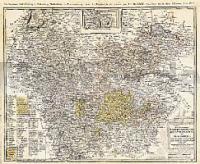
 | Fürstenthümer Grubenhagen, Calenberg, Wolfenbüttel und Blankenburg 1786 - Historische Landkarte Nachdruck Planokarte - gerollt von Güssefeld, Franz L. - Verlag Rockstuhl |
 | V522 Ivalo Topographische Karte 1:50.000 EUREF-FIN (Maastokarttat) Maanmittauslaitos / Lantmäteriverket Finnland - ProjektNord |
 | 5815 Wehen Topographische Landkarte Hessen 1:25.000 - ProjektNord (geplottete Ausgabe) |
 | Die Route Mittelfinnland *** SCHNÄPPCHEN *** Radwanderführer 1:100.000 Keski-Suomen reitti fillariopas / Central Finland Route cycling guide Finland Karttakeskus / Genimap Finnland |
 | 5718 Ilbenstadt Topographische Landkarte Hessen 1:25.000 - ProjektNord (geplottete Ausgabe) |
 | 1972 Kalisch Topographische Karte 1:25.000 Messtischblatt des Deutschen Reiches - Preußische Landesaufnahme / Reichsamt für Landesaufnahme - Faksimile ProjektNord |
 | 448 Strath Naver / Srath Nabhair & Loch Loyal - Wanderkarte Großbritannien 1:25.000 EXPLORER MAP - Ordnance Survey |
 | Oblast Brjansk 1:450.000 Straßenkarte / Touristenkarte - Russland Карта автодорог Брянской области и прилегающих территорий Russland |
 | A5 Magdalenafjorden Spitzbergen / Svalbard / Spitsbergen - Topographische Karte 1:100.000 Norsk Polarinstitutt |
 | USA Western Railroads / Highways 1:1.7 Mio. Landkarte - ITMB International Travel Maps (engl.) USA Western - Railroads - Highways |
 | 4145 Schönewalde Topographische Karte 1:25.000 Landesvermessungsamt Brandenburg (gefaltet) |
 | DuMont direkt Provence von Simon, Klaus |
| 4844 Döbeln Amtliche Topographische Landkarte 1:25.000 (Präsentationsgrafik) - Landesvermessungsamt Sachsen |
 | GreenVelo: Woiwodschaft Ermland-Masuren (Nordwestteil) 1:100.000 Radwanderkarte der Radwege - Steinpapier Woj. warminsko-mazurske cz. północno-zachodnia GreenVelo mapa tras rowerowych (papier skalny) Europilot - Daunpol - Polen |
 | 5116 Eibelshausen Topographische Landkarte Hessen 1:25.000 - ProjektNord (geplottete Ausgabe) |
 | WK 660 Firenze (Florenz) - Chianti 1:50.000 - Wanderkarte mit Broschüre KOMPASS |
 | 4050 Straupitz Topographische Karte 1:25.000 Landesvermessungsamt Brandenburg (gefaltet) |
 | Freudenstadt, Baiersbronn, Simmersfeld, Lossburg, Alpirsbach (Nr. 878) 1:25.000 - Wanderkarte mit Broschüre Simmersfeld - Lossburg -Alpirsbach KOMPASS |
 | USA: Appalachian Trail (Band 412) von Robert Stapper - Conrad-Stein-Verlag |
 | Erlebniskarte Illustrierte Deutschlandkarte - Wandkarte mit Metallbeleistung - ca. 100 x 70 cm - Krüger & Schönhoff druckbunt Verlag |