| << Deutschland: Historische Karten und Stadtpläne (im Bereich der heutigen Bundesrepublik) << Rockstuhl |
||
|
||
Zuletzt angesehene Artikel:
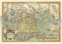
 | Sachsen - Meißen - Thüringen (Criginger) 1570 - Historische Landkarte Nachdruck Planokarte - gerollt von Abraham Ortelius - Verlag Rockstuhl |
 | 5318 Allendorf (Lumda) Topographische Landkarte Hessen 1:25.000 - ProjektNord (geplottete Ausgabe) |
 | 449 Strath Halladale & Strathy Point - Wanderkarte Großbritannien 1:25.000 EXPLORER MAP - Ordnance Survey |
 | Schrimm und Umgebung Stadtplan und Umgebungskarte 1:60.000 Touristische Landkarte Śrem miasto i gmina mapa TopMapa Pietruska & Mierkiewicz - Polen |
 | M-34-49/50 Bytom Plot aus der Kartengrundlage der amtliche topographische Karte Polen 1:100.000 ProjektNord |
 | 294 Market Weighton and Yorkshire Wolds Central - Wanderkarte Großbritannien 1:25.000 EXPLORER MAP - Active Map LAMINIERT - Ordnance Survey |
 | Dolomiti di Brenta - Madonna di Campiglio - Andalo - Molveno 1:25.000 - Wanderkarte mit Broschüre (Blatt 688) KOMPASS |
 | Ligurien 1:200.000 - Straßenkarte Italien Liguria Libreria Geografica - Italien |
 | L4946 Meißen 1:50.000 Amtliche Topografische Landkarte - Landesvermessungsamt Sachsen |
 | Schlesische Beskiden - Saybuscher Beskiden Landkarte 1:50.000 Landkarte Beskid Śląski i Żywiecki mapa ExpressMap - Polen |
 | Ukraine Straßenkarte 1:1 Mio - Hardcover (englische / lateinische Ausgabe) Ukraine road map Kartografija - ukrmap Ukraine |
 | Loviisa - Pellinki - Kaunissaari Wassersportkarte / Bootskarte 1:60.000 Karttakeskus Loviisa Pellinki Kaunissaari, Water Touring Map Karttakeskus - Finnland |
 | Ufa Stadtplan 1:30.000 - Russland Уфа - План города FGUP - Omskaja kartografičeskaja fabrika |
| 4749 Königsbrück (35) - Geologische Karte 1:25.000 (GK25) Grundlage Messtischblatttopographie Sächsisches Landesamt für Umwelt, Landwirtschaft und Geologie |
 | Demer & Dijle wandelnetwerk Vlaams-Brabant kaart + infogids (wasserfest) Wanderkarte 1:20.000 - Belgien Wandelnetwerk Belgien |
 | Istanbul Provinzkarte 1:170.000 Istanbul - Il Haritasi Mepmedya Türkei |
 | Naturparks Schleswig-Holstein - 27 Wanderungen zwischen Nord- und Ostsee - Band 428 - von Tonia Körner - Stein, Conrad, Verlag |
 | Wasserfallweg mit Lieserpfad von Bad Münstereifel nach Lieser - von Iris Schulte Renger - Conrad Stein Verlag GmbH |
 | 56 Blanensko, Boskovicko Wanderkarte Tschechien 1:50.000 - SHOCart |
| 5340 Planitz-Ebersbrunn (124) - Geologische Karte 1:25.000 (GK25) Grundlage Vollbornsche Äquidistantenkarte Sächsisches Landesamt für Umwelt, Landwirtschaft und Geologie |