| << Deutschland: Historische Karten und Stadtpläne (im Bereich der heutigen Bundesrepublik) << Rockstuhl |
||
|
||
Zuletzt angesehene Artikel:
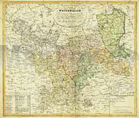
 | General Charte Königreich Westphalen 1809 - Historische Landkarte Nachdruck Planokarte - gerollt von Streit, Friedrich W. - Verlag Rockstuhl |
 | 0236-1 FRÃMISTA Topographische Landkarte 1:25.000 Spanien (Grundlage MTN25) Instituto Geográfico Nacional - CNIG Spanien - ProjektNord |
 | 0832-4 ESTACIÃN DE ZÃJAR Topographische Landkarte 1:25.000 Spanien (Grundlage MTN25) Instituto Geográfico Nacional - CNIG Spanien - ProjektNord |
 | 0945-2 VALENZUELA Topographische Landkarte 1:25.000 Spanien (Grundlage MTN25) Instituto Geográfico Nacional - CNIG Spanien - ProjektNord |
 | 0497-2 MAS DE PONà Topographische Landkarte 1:25.000 Spanien (Grundlage MTN25) Instituto Geográfico Nacional - CNIG Spanien - ProjektNord |
 | 0236-3 AMUSCO Topographische Landkarte 1:25.000 Spanien (Grundlage MTN25) Instituto Geográfico Nacional - CNIG Spanien - ProjektNord |
 | 0148-4 VIELHA Topographische Landkarte 1:25.000 Spanien (Grundlage MTN25) Instituto Geográfico Nacional - CNIG Spanien - ProjektNord |
 | 0862-4 SANTA ELENA Topographische Landkarte 1:25.000 Spanien (Grundlage MTN25) Instituto Geográfico Nacional - CNIG Spanien - ProjektNord |
 | 0972-2 CÃLLAR Topographische Landkarte 1:25.000 Spanien (Grundlage MTN25) Instituto Geográfico Nacional - CNIG Spanien - ProjektNord |
 | 0496-4 ALFARA DE CARLES Topographische Landkarte 1:25.000 Spanien (Grundlage MTN25) Instituto Geográfico Nacional - CNIG Spanien - ProjektNord |
 | Autonome Republik Krim 1:250.000 Landkarte, StraÃenkarte mit administrativen Grenzen - Ukraine Awtonomna Respublika Krym / Автономна Республіка Крим Kartografija - ukrmap Ukraine |
 | SENDER DE LA MEDITERRÃNIA Touristischer Wanderführer - Wanderkarte 1:50.000 GR 92 SUD De Vallvidrera (Barcelona) al Pont de Moliner (Ulldecona) Editorial Alpina Spanien |
 | 0489-3 TORREMOCHA DEL PINAR Topographische Landkarte 1:25.000 Spanien (Grundlage MTN25) Instituto Geográfico Nacional - CNIG Spanien - ProjektNord |
 | Losinj - Unije - Susak *** SCHNÃPPCHEN *** mit Wanderwegen und Radwegen - Wanderkarte - Fahrradkarte 1:35.000-1:40.000 Kroatien Lošinj - Unije - Susak ProjektNord |
 | DEUTSCHLAND Dreissigjähriger Krieg 1618-1648 - Historische Landkarte Nachdruck Planokarte - gerollt von Bruno Hassenstein - Reprint der Auflage von Justus Perthes Gotha 1875 - Verlag Rockstuhl |
 | 4 CASTRO LABOREIRO (MELGAÃO) Topographische Landkarte Wanderkarte und Fahrradkarte Portugal 1:25.000 004 Mapa topográfico - Mapa de caminhadas - Portugal 1:25.000 ProjektNord |
 | 0011-3 NAVIA Topographische Landkarte 1:25.000 Spanien (Grundlage MTN25) Instituto Geográfico Nacional - CNIG Spanien - ProjektNord |
 | 0387-3 MIRALSOT Topographische Landkarte 1:25.000 Spanien (Grundlage MTN25) Instituto Geográfico Nacional - CNIG Spanien - ProjektNord |
 | 0485-1 EL ATAZAR Topographische Landkarte 1:25.000 Spanien (Grundlage MTN25) Instituto Geográfico Nacional - CNIG Spanien - ProjektNord |
 | 0614-3 MANZANERA Topographische Landkarte 1:25.000 Spanien (Grundlage MTN25) Instituto Geográfico Nacional - CNIG Spanien - ProjektNord |