| << Deutschland: Historische Karten und Stadtpläne (im Bereich der heutigen Bundesrepublik) << Rockstuhl |
||
|
||

Zuletzt angesehene Artikel:
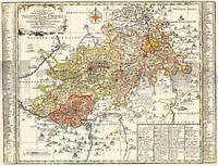
 | Vogtland - Neustädtische Kreis und die Ãmter Arnshaugk, Miltenfurth, Weyda 1757 - Historische Landkarte Nachdruck Planokarte - gerollt von Schenk, Peter - Verlag Rockstuhl |
 | 7328 Wittislingen Topographische Landkarte Bayern 1:25.000 - Normalausgabe - ProjektNord (geplottete Ausgabe) - Grundlage amtliche Topographische Karte Bayern DTK25 |
 | 6427 Uffenheim Topographische Landkarte Bayern 1:25.000 - Normalausgabe - ProjektNord (geplottete Ausgabe) - Grundlage amtliche Topographische Karte Bayern DTK25 |
 | 8136 Holzkirchen Topographische Landkarte Bayern 1:25.000 - Normalausgabe - ProjektNord (geplottete Ausgabe) - Grundlage amtliche Topographische Karte Bayern DTK25 |
 | 7345 Vilshofen Topographische Landkarte Bayern 1:25.000 - Normalausgabe - ProjektNord (geplottete Ausgabe) - Grundlage amtliche Topographische Karte Bayern DTK25 |
 | 4912 Drolshagen - Wanderkarte mit Wanderwegen (geplottete Ausgabe) ProjektNord - Grundlage Amtliche topographische Karte 1:25.000 Landesvermessungsamt Nordrhein-Westfalen |
 | Oblast Kaluga - topografischer Atlas 1:200.000 Калужская область - Региональный атлас FGUP 439 Central´naja experimental´naja voenno-kartografičeskaja fabrika |
 | 6932 Nennslingen Topographische Landkarte Bayern 1:25.000 - Normalausgabe - ProjektNord (geplottete Ausgabe) - Grundlage amtliche Topographische Karte Bayern DTK25 |
 | 5636 Naila Topographische Landkarte Bayern 1:25.000 - Normalausgabe - ProjektNord (geplottete Ausgabe) - Grundlage amtliche Topographische Karte Bayern DTK25 |
 | 1588 Kreuzburg in OstpreuÃen Topographische Karte 1:25.000 Messtischblatt des Deutschen Reiches - PreuÃische Landesaufnahme / Reichsamt für Landesaufnahme - Faksimile ProjektNord |
| Die Ardennenschlacht - Belgien - Militär-Erbe 1:100.000 The Battle of the Ardennes NGI Touristische Landkarte Belgien |
 | UK 50-1 Naturpark Bayerische Rhön - Bad Kissingen - Hammelburg - Bad Neustadt a.d.Saale - Bad Brückenau - Mellrichstadt - Bischofsheim a.d.Rhön - Wanderkarte Bayern 1:50.000 mit Wanderwegen und Radwanderwegen, GPS-Gitter - Landesamt für Digitalisierung, Breitband und Vermessung (Landesvermessungsamt Bayern) |
 | Pasewalk, Szczecin (Stettin) und Umgebung - Radwander- und Wanderkarte 1:50.000 (Nr. 219) Ausflüge zwischen dem Randowbruch, Brüssow, Krugsdorf, Krackow, Boock, Dobra und Police. Radwander- und Wanderkarte, Radtourenvorschläge mit Entfernungsangaben. Viele Tipps zu Sehenswürdigkeiten. GPS-fähig Dr. Barthel Verlag |
 | 6237 Grafenwöhr Topographische Landkarte Bayern 1:25.000 - Normalausgabe - ProjektNord (geplottete Ausgabe) - Grundlage amtliche Topographische Karte Bayern DTK25 |
 | Bukovina 1:160.000 Topographische Radwanderkarte - Mountainbikekarte Harta turistica Bucovina M 1:160.000 Schubert & Franzke Rumänien |
 | BergstraÃe Odenwald Nord, Bensheim - Reichelsheim - Michelstadt Rad- und Wanderkarte mit Ausflugszielen, Einkehr- und Freizeittipps sowie Mountainbike-Erlebnissen, wetterfest, reiÃfest, abwischbar, GPS-genau. 1:50000 - von - Freytag-Berndt und ARTARIA PUBLICPRESS |
 | 7434 Hohenwart Topographische Landkarte Bayern 1:25.000 - Normalausgabe - ProjektNord (geplottete Ausgabe) - Grundlage amtliche Topographische Karte Bayern DTK25 |
 | 6738 Burglengenfeld Topographische Landkarte Bayern 1:25.000 - Normalausgabe - ProjektNord (geplottete Ausgabe) - Grundlage amtliche Topographische Karte Bayern DTK25 |
 | 6538 Schmidgaden Topographische Landkarte Bayern 1:25.000 - Normalausgabe - ProjektNord (geplottete Ausgabe) - Grundlage amtliche Topographische Karte Bayern DTK25 |
 | Trail-Karte (2) Mountainbike Harz: Braunlage - Schierke - St. Andreasberg - Brocken 1:25.000 (wasserfest - reiÃfest) 65 Trails klassifiziert, 24 Trails beschrieben, Bewertung nach STS, Wasser- und reiÃfeste Mountainbike-Karte - Schmidt-Buch-Verlag |