 Vorzügliche Wanderkarten, Radwanderkarten und Stadtpläne  Stadtplanbeispiel aus der Serie Stadtplanbeispiel aus der Serie
Kartenbeispiel der Umgebungskarten Wanderkartenbeispiel aus der Serie Radwanderkartenbeispiel aus der Serie Blattübersicht Radwander- und Wanderkarten Blattübersicht Zick-Zack-Karten Blattübersicht Stadtpläne und Ausflugskarten Kartenausschnitt
|
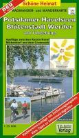
Potsdamer Havelseen, Blütenstadt Werder und Umgebung - Radwander- und Wanderkarte 1:35.000 (Nr. 088) Ausflüge zwischen Ketzin/Havel, Michendorf und dem Grunewald. Radwander- und Wanderkarte, Mit dem genauern Verlauf des Havel-Radweges. GPS-fähig. Mit QR-Code Dr. Barthel Verlag
EAN / ISBN: 9783895910883
Preis: EUR 5.90
|
| 
