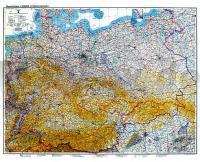
| << Deutschland: Historische Karten und Stadtpläne (im Bereich der heutigen Bundesrepublik) << Rockstuhl |
  | |
Zuletzt angesehene Artikel:
![]() | Historische Übersichtskarte: DEUTSCHLAND - Stand 8. Februar 1940 Bodenorganisation Deutsche Luftwaffe - Herausgegeben vom REICHSLUFTAHRTMINISTERIUM, Berlin 1938 - Verlag Rockstuhl |
![]() | 443.14 Amtliche topographische Karte 1:25.000 Polen |
![]() | Roztocze Süd Touristische Landkarte 1:50.000 (Blatt 376) Roztocze Południowe część polska mapa CartoMedia - Polen |
![]() | 411.1 Amtliche topographische Karte 1:50.000 Polen |
![]() | 352.12 Amtliche topographische Karte 1:25.000 Polen |
![]() | Wielichowo Stadt und Gemeinde Stadtplan und Touristische Landkarte 1:50.000 Wanderkarte, Radwanderkarte, Freizeitkarte, Kanurouten Wielichowo miasto i gmina mapa TopMapa Pietruska & Mierkiewicz - Polen |
![]() | 35-1 Topographische Karte 1:100.000 der Tschechischen Republik Zakladnà mapa Ceská republika - Cesky urad zememericky a katastralni - ProjektNord |
![]() | Ille et Vilaine - Randonnées en Haute-Bretagne (Blatt 5) Pays de Rennes - Freizeit und Ausflugs-Landkarte 1:50.000 Plein Air - IGN Frankreich |
![]() | Hydra Reiseführer (englisch) Road Editions - Nakas Road Cartography - Griechenland |
![]() | Wanderungen Flachgau und Rupertiwinkl - Wanderführer 71 Touren für Familien und Genusswanderer - von Dieter Buck - Plenk-Verlag |
![]() | 332.21 Amtliche topographische Karte 1:25.000 Polen |
![]() | Murcia Landkarte 1:200.000 Straßenkarte Spanien - CNIG Centro Nacional de Información Geográfico |
![]() | Mecklenburgische Seen Ost 1:75.000 Landkarte - Bikeline Radkarte (RK-MV07) Deutschland Wasser- und reißfest. UTM-Netz - Esterbauer |
![]() | USA West Straßenkarte 1:2 Mio. USA West / Etats Unis Ouest Internationale Landkarte IGN |
![]() | Europa-Radweg Eiserner Vorhang 1:85.000 Von Hof nach Szeged, Deutschland, Tschechien, Österreich, Slowakei, Ungarn, Slowenien, Kroatien, 1.730 km - bikeline Radtourenbuch Esterbauer |
![]() | Welt politisch Explorer Laminierte PLANO-Karte 1:51.969 Mio. (Format: 81 x 51 cm) - gerollt im Plastikrohr World political flat map explorer - laminated National Geographic |
![]() | Republik Baschkortostan 1:800.000 - Ufa Stadtplan - Russland Карта Башкортостан Респ. и г.Уфа / Karta Respublika Bashkortostan / Ufa plan goroda Roskartografia |
![]() | 331.21 Amtliche topographische Karte 1:25.000 Polen |
![]() | 439 Coigach & Summer Isles - laminierte Wanderkarte Großbritannien 1:25.000 EXPLORER MAP - Ordnance Survey |
![]() | 435.1 Amtliche topographische Karte 1:50.000 Polen |


