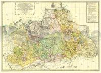
| << Deutschland: Historische Karten und Stadtpläne (im Bereich der heutigen Bundesrepublik) << Rockstuhl |
  | |
Zuletzt angesehene Artikel:
![]() | MARKGRAFSCHAFT NIEDERLAUSITZ 1757 - historische Landkarte - Nachdruck - von Peter Schenk - Plano gerollt - Verlag Rockstuhl |
![]() | L3232 Lypyrtti Topographische Karte 1:25.000 EUREF (Peruskartta) Maanmittauslaitos / Lantmäteriverket Finnland - ProjektNord |
![]() | Luftfahrtkarte ICAO Schweiz und Liechtenstein 1:500.000 Topographische Landeskarte der Schweiz - swisstopo |
![]() | 6009 Strassenkarte der Schweiz 1:200.000 Topographische Landeskarte der Schweiz (doppelseitig) - swisstopo |
![]() | 23 Kassandra 1:50.000 Wanderkarte (wasserfest) Griechische Berge (GPS) - Nakas Road Cartography / Road Editions Griechenland |
![]() | Katalonien - Aragon - Andorra Regionale Straßenkarte 1:400.000 (Blatt 574) Michelin (Ausgabe für den deutschen Markt) Spanien |
![]() | L5111 Puhari Topographische Karte 1:25.000 EUREF (Peruskartta) Maanmittauslaitos / Lantmäteriverket Finnland - ProjektNord |
![]() | L4331 Tiiskeri-Digskär Topographische Karte 1:25.000 EUREF (Peruskartta) Maanmittauslaitos / Lantmäteriverket Finnland - ProjektNord |
![]() | L3334 Perniö Topographische Karte 1:25.000 EUREF (Peruskartta) Maanmittauslaitos / Lantmäteriverket Finnland - ProjektNord |
![]() | L4431 Topographische Karte 1:25.000 EUREF (Peruskartta) Maanmittauslaitos / Lantmäteriverket Finnland - ProjektNord |
![]() | Parco Regionale della Vena del Gesso Romagnola (Blatt 10 BO) Wanderkarte 1:25.000 - Valli del Santerno - Senio - Sintria - Lamone - l´Escursionista Editore Italien Carta escursionistica del Parco Regionale della Vena del Gesso Romagnola con guida a 14 escursioni |
![]() | Sicherheit und Risiko in Fels und Eis (Band 2) Erlebnisse und Ergebnisse aus der Sicherheitsforschung des Deutschen Alpenvereins - von Pit Schubert - Bergverlag Rother |
![]() | L3112 Lumparland Topographische Karte 1:25.000 EUREF (Peruskartta) Maanmittauslaitos / Lantmäteriverket Finnland - ProjektNord |
![]() | 6117 Darmstadt West Topographische Landkarte Hessen 1:25.000 - ProjektNord (geplottete Ausgabe) |
![]() | L3124 Enklinge Topographische Karte 1:25.000 EUREF (Peruskartta) Maanmittauslaitos / Lantmäteriverket Finnland - ProjektNord |
![]() | L3123 Kumlinge Topographische Karte 1:25.000 EUREF (Peruskartta) Maanmittauslaitos / Lantmäteriverket Finnland - ProjektNord |
![]() | L4321 Porvoo Topographische Karte 1:25.000 EUREF (Peruskartta) Maanmittauslaitos / Lantmäteriverket Finnland - ProjektNord |
![]() | L3243 Vehmaa Topographische Karte 1:25.000 EUREF (Peruskartta) Maanmittauslaitos / Lantmäteriverket Finnland - ProjektNord |
![]() | L2431 Högsten Topographische Karte 1:25.000 EUREF (Peruskartta) Maanmittauslaitos / Lantmäteriverket Finnland - ProjektNord |
![]() | Srem und Fruška Gora - 1:120.000 Touristische Straßenkarte Srem i Fruška Gora Merkur-SV Serbien |


