Willkommen bei MapFox
Wurde Ihre Bestellung bestätigt? Wenn nicht - gab es evtl. ein SERVER-Problem! Bitte kontaktieren Sie uns! +++ Buchhändler-Anfragen erwünscht +++
Warenkorb
Artikel: 0 - € 0.00
Zur Kasse
Widerruf Impressum Kontakt Versandkosten AGB
Pembrokeshire South - Top 10 Walks Series Circular Walks along the Wales Coast Path - Dennis Kelsall - Mara Books
<< Großbritannien: Wanderführer + Kletterführer
 
Cover

One of the series of books in the new Top 10 Walks: Wales Coast Path series. Handy, pocket-sized, full colour walking guides written by experts. Each volume outlines the most popular circular walks along key sections of the coast path.

With clear information, an overview and introduction for each walk, expertly written numbered directions, enhanced Ordnance Survey maps, superb, eye-grabbing panoramic photographs, and interpretation of points of interest along the way, these guides set a new standard in reliability, clarity and ease-of-use.

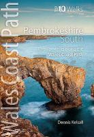
Featured walks include: Marloes Peninsula, Dale Head, Angle Peninsula, Freshwater West & Angle, Elegug Stacks & the Range, Broad Haven & Bosherston, Stackpole Estate, Manorbier, Tenby & Giltar Point and Colby Woodland Garden.

Kartenausschnitt

Kartenbeispiel

Pembrokeshire South - Top 10 Walks Series Circular Walks along the Wales Coast Path - Dennis Kelsall - Mara Books
EAN / ISBN: 9781908632302
Preis: EUR 14.90

Bestellartikel: versandfertig in ca. 1-3 Wochen. Dieser Artikel wird speziell für Sie bestellt. Keine Rücknahme!
Produkt EUR Anzahl Bestellen
Pembrokeshire South - Top 10 Walks Series Circular Walks along the Wales Coast Path - Dennis Kelsall - Mara Books 14.90
Versandkostenfrei in Deutschland ab 30,- Bestellwert

incl. MwSt.

Stichworte, die bei der Suche nützlich sein könnten:
Pembrokeshire - Pembrokeshire South Wanderführer - Pembrokeshire South - Großbritannien - Großbritannien Wanderführer - Großbritannien Trekkingführer - Großbritannien Klettern - Großbritannien Kletterführer

Zuletzt angesehene Artikel:

CoverPembrokeshire South - Top 10 Walks Series Circular Walks along the Wales Coast Path - Dennis Kelsall - Mara Books

Cover102 Tinos 1:40.000 Landkarte Griechische Inseln - Road Editions - Griechenland

CoverSOMME - AMIENS - ABBEVILLE - PNR BAIE DE SOMME PICARDIE MARITIME (Blatt D80) Département-Landkarte Frankreich 1:100.000
SOMME - Carte départementale - IGN Frankreich

Cover19 Kaikoura Topographische Landkarte Neuseeland 1:250.000 Land Information New Zealand

Cover0917SB PLOEUC-SUR-LIE - MONCONTOUR GPS Amtliche Topographische Wanderkarte Frankreich 1:25.000 - série bleue (IGN)

Cover11 Gisborne Topographische Landkarte Neuseeland 1:250.000 Land Information New Zealand

Noch kein Cover vorhandenPik Lenin (Blatt 13) Topografische Landkarte 1:200.000
Pik Lenina - Kirgisistan

CoverWinsen (Aller) Topographische Wanderkarte mit Wanderwegen und Radwegen 1:25.000 Niedersachsen - ProjektNord

Noch kein Cover vorhanden2510SB Noyon - Chauny GPS Amtliche Topographische Wanderkarte Frankreich 1:25.000 - série bleue (IGN)

CoverChina - Administrative Referenzkarte 1:6.5 Mio. - geografische Karte
CHINA basic reference map GiziMap

Noch kein Cover vorhanden1532SB Pons - Pérignac GPS Amtliche Topographische Wanderkarte Frankreich 1:25.000 - série bleue (IGN)

Cover2642ET SAINT-GUILHEM-LE-DESERT - Cirque de Navecelles - Topographische Wanderkarte Frankreich 1:25.000 TOP 25 IGN

Noch kein Cover vorhandenCE15 Topographische Landkarte Neuseeland 1:50.000 Land Information New Zealand

Cover10/5-6 BEVERBEEK NGI 1:25.000 Topographische Landkarte Belgien