| << Großbritannien: Wanderführer + Kletterführer |
||
|
||
Zuletzt angesehene Artikel:
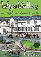
 | Wye Valley - 40 Berg- & Flußuferwanderungen Englischsprachiger Wanderführer - POCKET MOUNTAINS LTD Wye Valley - 40 Hill and Riverside Walks - 40 circular routes |
 | 326 Ayr & Troon - Wanderkarte Großbritannien 1:25.000 EXPLORER MAP - Ordnance Survey |
 | 199 Lampeter / Llanbedr Pont Steffan - Wanderkarte Großbritannien 1:25.000 EXPLORER MAP - Ordnance Survey |
 | Great Mountain Days in the Pennines - 50 classic hillwalking challenges Wanderführer (englisch) Cicerone Großbritannien |
 | 162 Greenwich & Gravesend - Wanderkarte Großbritannien 1:25.000 EXPLORER MAP - Ordnance Survey |
 | 163 Gravesend & Rochester - Wanderkarte Großbritannien 1:25.000 EXPLORER MAP - Ordnance Survey |
 | 432 Black Isle - Wanderkarte Großbritannien 1:25.000 EXPLORER MAP - Ordnance Survey |
 | 343 Motherwell & Coatbridge - Wanderkarte Großbritannien 1:25.000 EXPLORER MAP - Ordnance Survey |
 | The Cleveland Way and the Yorkshire Wolds Way With the Tabular Hills Walk - Wanderführer - Cicerone Großbritannien (englisch) |
 | OL16 The Cheviot Hills - Wanderkarte Großbritannien 1:25.000 NEW EXPLORER MAP - Ordnance Survey |