Willkommen bei MapFox
Wurde Ihre Bestellung bestätigt? Wenn nicht - gab es evtl. ein SERVER-Problem! Bitte kontaktieren Sie uns! +++ Buchhändler-Anfragen erwünscht +++
Warenkorb
Artikel: 0 - € 0.00
Zur Kasse
Impressum Kontakt Versandkosten AGB
Tenerife Bus & Touring Map Discovery Walking Guides Ltd
<< Spanien: Wanderkarten - verschiedene Verlage
<< Discovery Walking Guides Ltd.
<< Teneriffa
 
Cover

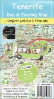
Fully detailed up-to-date map of Tenerife designed for both Titsa bus service users and car drivers. Updated bus routes along details of the new Santa Cruz - La Laguna Tram service - a `Must Ride` experience, updated bus timetables and details of the Bono-Via discount ticket, updated island road map and updated street plans.

Tenerife Bus & Touring Map has been drawn at a scale of 1:100,000 with particular emphasis on navigation by bus service and hire car. Full place name index makes finding your destination quick and easy, while the distance chart will tell you how far you will drive to get there. Useful map symbols include petrol stations, rural bar/restaurants, miradors and Tenerife`s two out-of-town hypermarkets.

TITSA Bus Service Routes are clearly shown on the map along with the termini of various routes. Timetable Information is given for the majority of Titsa`s routes, including all of those likely to be used by Visitors to Tenerife. BONO-VIA is a simple pre-payment card giving big discounts off the already budget priced fares, so we fully explain where to buy your Bono-Via and how to use it. 2010 edition fully updated for Titsa`s timetable changes.

Large scale Street Plans, including Bus Stops and Bus Stations, of Playa las Americas, Los Cristianos, Los Gigantes/Playa Santiago, Golf del Sur/Amarilla Golf, Costa del Silencio, Puerto de la Cruz and Santa Cruz, are on the reverse of the map.

5 km grid with datum information makes this map GPS Enabled for those using these modern navigation devices.

Kartenbeispiel

Tenerife Bus & Touring Map Discovery Walking Guides Ltd
EAN / ISBN: 9781782750703
Preis: EUR 7.90

Bestellartikel: versandfertig in ca. 1-3 Wochen. Dieser Artikel wird speziell für Sie bestellt. Keine Rücknahme!
Produkt EUR Anzahl Bestellen
Tenerife Bus & Touring Map Discovery Walking Guides Ltd 7.90
Versandkostenfrei in Deutschland ab 30,- Bestellwert

incl. MwSt.

Stichworte, die bei der Suche nützlich sein könnten:
Teneriffa Linienbusse - Kanarische Inseln - Teneriffa öffentliche Verkehrsmittel - Teneriffe - Islas Canarias - Tenerife - Teneriffa Busverkehr - Teneriffa - Spanien Wanderkarten - Spain hiking maps - Discovery Walking Guides - Kanarische Inseln Wanderkarten - Madeira Wanderkarten - Kanarische Inseln - Canarische Inseln - Teneriffa Landkarten - Teneriffa Wanderkarten - Teneriffa Wanderführer - Teneriffa Reiseführer - Islas Canarias - Tenerife maps

Zuletzt angesehene Artikel:

CoverTenerife Bus & Touring Map Discovery Walking Guides Ltd

CoverKreuzfahrten Dubai und Emirate Mit Abu Dhabi, Bahrain, Oman und Katar - von Werner K. Lahmann - TRESCHER

Cover92 Burfellsheidi Topographische Karte Island 1:100.000 - Ferdakort
92 BÚRFELLSHEIÐI - Atlaskort - Ferðakort

CoverHansestadt Wismar, Insel Poel, Boltenhagen und Umgebung - Radwander- und Wanderkarte 1:50.000 (Nr. 189) Ausflüge zwischen Neukloster, Neubukow, Klütz, Rerik und Grevesmühlen. 1:50000 Mit Citykarte Wismar. Radwander- und Wanderkarte, Radtourenvorschläge m. Entfernungsangaben. Viele Tipps zu Sehenswürdigkeiten. GPS-fähig. Wetterfest, reißfest Dr. Barthel Verlag

CoverLanzarote Wanderkarte 1:40.000 Tour & Trail (wasserfest) DISCOVERY WALKING GUIDES LTD
Lanzarote Tour & Trail (Super-Durable version)

CoverPennsylvania 1:150.000 State Recreation Atlas USA National Geographic

CoverUK 50-54 Chiemsee - Chiemgauer Alpen - Traunstein - Wasserburg a. Inn - Haag i.OB. - Simssee - Kaiserwinkl Wanderkarte Bayern 1:50.000 mit Wanderwegen und Radwanderwegen, GPS-Gitter - Landesamt für Digitalisierung, Breitband und Vermessung (Landesvermessungsamt Bayern)

CoverNordwest-Island (Blatt 1) - Touristische Landkarte 1:250.000
Norðvesturland - ferðakort 1 Landmælingar - Island

Noch kein Cover vorhanden2968 Samotschin Topographische Karte 1:25.000 Messtischblatt des Deutschen Reiches - Preußische Landesaufnahme / Reichsamt für Landesaufnahme - Faksimile ProjektNord

CoverTschenstochau 1:23.500 Stadtplan Polen
MAPA SKLADANA CZESTOCHOWY Wydawnictwo Pietka - Polen

CoverGranada und Umgebung Amtliche topographische Landkarte 1:50.000 Spanien (M.T.N.)
Granada y su entorno - (en carpeta de plástico) Mapa Topográfico Nacional de Espana (MTN50)

Noch kein Cover vorhanden174.14 Amtliche topographische Karte 1:25.000 Polen

Cover179 Canterbury & East Kent - Dover & Margate - Wanderkarte Großbritannien 1:50.000 Active Laminiert LANDRANGER MAP - Ordnance Survey

Cover083 Newton Stewart & Kirkcudbright, Gatehouse of Fleet - Wanderkarte Großbritannien 1:50.000 Active Laminiert LANDRANGER MAP - Ordnance Survey

Cover05 Radlje ob Dravi - Topographische Landkarte Slowenien 1:50.000 - Amtliche Kartengrundlage ProjektNord

CoverTour en Bugey - Sud du massif jurassien - Topocarte - Réf. TC012 Topographische Wanderkarte - FFRP (Fédération française de randonnée pédestre) Frankreich

Noch kein Cover vorhanden135.34 Amtliche topographische Karte 1:25.000 Polen

CoverBritish Columbia (Kanada) 1:1.250.000 *** SCHNÄPPCHEN *** Landkarte - ITMB International Travel Maps (engl.)

Cover01-44 Klasterec nad Ohri Topographische Karte 1:50.000 der Tschechischen Republik
Zakladní mapa Ceská republika - Cesky urad zememericky a katastralni - ProjektNord

CoverGreenVelo: Hinterpommern - Dreistadt Danzig 1:100.000 Radwanderkarte der Radwege - Steinpapier
Pomorze, Trójmiasto i okolice GreenVelo mapa tras rowerowych (papier skalny) Europilot - Daunpol - Polen