Willkommen bei MapFox
Wurde Ihre Bestellung bestätigt? Wenn nicht - gab es evtl. ein SERVER-Problem! Bitte kontaktieren Sie uns! +++ Buchhändler-Anfragen erwünscht +++
Warenkorb
Artikel: 0 - € 0.00
Zur Kasse
Impressum Kontakt Versandkosten AGB
Antarktischer Kontinent Exploration Map 1:6.8 Mio
Antarctic Continent - Exploration map - Penetration Routes, Discovery Ships, Human Presence ZAGIER & URRUTY PUBLICATIONS
<< Antarktis
<< Zagier & Urruty Publications
 
Cover

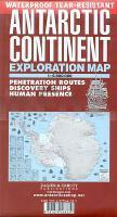
Detailreiche Landkarte des Antarktischen Kontinents. Enthält die Stationen und historischen Stätten, die Routen der Polarexpeditionen sowie 11 Karten über die einzelnen Expeditionsreisen von James Cook bis Richard Byrd sowie Zeichnungen von zahlreichen Entdeckerschiffen.

(Achtung: Dies ist keine zur Navigation geeignete Seekarte!)

Kartenausschnitt

Kartenbeispiel

Antarktischer Kontinent Exploration Map 1:6.8 Mio
Antarctic Continent - Exploration map - Penetration Routes, Discovery Ships, Human Presence ZAGIER & URRUTY PUBLICATIONS
EAN / ISBN: 9781879568334
Preis: EUR 17.90

Bestellartikel: versandfertig in ca. 1-3 Wochen. Dieser Artikel wird speziell für Sie bestellt. Keine Rücknahme!
Produkt EUR Anzahl Bestellen
Antarktischer Kontinent Exploration Map 1:6.8 Mio
Antarctic Continent - Exploration map - Penetration Routes, Discovery Ships, Human Presence ZAGIER & URRUTY PUBLICATIONS
17.90
Versandkostenfrei in Deutschland ab 30,- Bestellwert

incl. MwSt.

Stichworte, die bei der Suche nützlich sein könnten:
Antarktis - Antarktika - Antarktis-Expeditionen - Südpol - Antarktis - Antarctica - Südpol - Antarktis Landkartenverkauf - Antarktis Landkarten - Antarktiskarten - Antarktis Karten - Antarktis Reiseführer - Antarktis Kartographie - Antarktis Atlanten - Antarktis Wanderkarten - Antarktis Kartografie - Zagier & Urruty Publications - Urruty - Zagier - Zagier Urruty - Chile Wanderkarten - Argentinien Wanderkarten - Patagonien Trekkingkarten - Feuerland Trekkingkarten

Zuletzt angesehene Artikel:

CoverAntarktischer Kontinent Exploration Map 1:6.8 Mio
Antarctic Continent - Exploration map - Penetration Routes, Discovery Ships, Human Presence ZAGIER & URRUTY PUBLICATIONS

Cover1847OT ST-BERTRAND DE COMMINGES Topographische Wanderkarte Frankreich 1:25.000 TOP 25 IGN - (GPS)

Noch kein Cover vorhanden3433OT ALLEVARD - BELLEDONE NORD Topographische Wanderkarte Frankreich 1:25.000 TOP 25 IGN - (GPS)

Noch kein Cover vorhanden3423ET BAUME-LES-DAMES Topographische Wanderkarte Frankreich 1:25.000 TOP 25 IGN - (GPS)

Cover2739OT MONT-LOZERE - FLORAC Topographische Wanderkarte Frankreich 1:25.000 TOP 25 IGN

CoverColumbia - West Columbia Street Map (Ohio) Stadtplan - Rand McNally - USA

Noch kein Cover vorhanden2343ET CASTRES / LE SIDOBRE Topographische Wanderkarte Frankreich 1:25.000 TOP 25 IGN

CoverLos Angeles street map, CA Stadtplan - Rand McNally - USA

Cover3325OT ARBOIS - SALINS-LES-BAINS Topographische Wanderkarte Frankreich 1:25.000 TOP 25 IGN - (GPS)

CoverFischkarte Südböhmen 1:190.000
Jizní Cechy - rybárska mapa - SHOCart - Tschechien

Cover1211OT LES PIEUX Topographische Wanderkarte Frankreich 1:25.000 TOP 25 IGN - (GPS)

Cover2549OT BANYULS - Col du Perthus - Côte Mermeille - Topographische Wanderkarte Frankreich 1:25.000 TOP 25 IGN - (GPS)

CoverPerth & the SW Western Australia 4WD Camping escapes (spiralo) 1:700.000 HEMA Maps

Cover0916OT SAINT-BRIEUC Topographische Wanderkarte Frankreich 1:25.000 TOP 25 IGN - (GPS)

Cover3531ET SAINT-GERVAIS-LES-BAINS Topographische Wanderkarte Frankreich 1:25.000 TOP 25 IGN

Cover2943ET ARLES Topographische Wanderkarte Frankreich 1:25.000 TOP 25 IGN

Cover1116ET SAINT-MALO Topographische Wanderkarte Frankreich 1:25.000 TOP 25 IGN - (GPS)

CoverAusflugsgasthöfe in Südtirol Mit Wandervorschlägen und Kulturtipps - Folio

Cover4351OT CERVIONE Topographische Wanderkarte Frankreich 1:25.000 TOP 25 IGN

CoverAustralien Ost 1:1.8 Mio. *** SCHNÄPPCHEN *** Landkarte Reise-Know-How Verlag - world mapping project