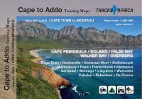
 SC1 & SC2 : Cape Peninsula, Boland, Winelands, False Bay, Walker Bay and the Overberg region The Cape to Addo map series covers the southern parts of the Western Cape of South Africa in a series of eight highly detailed maps, printed on four sheets of A1 durable paper. We start in Cape Town in the west and move along the southern coast through the Overberg, Winelands, Garden Route, Klein Karoo R62, Baviaanskloof to eventually arrive in the Addo National Park up to Gqeberha (Port Elizabeth) in the east. The maps are highly detailed and well researched. Our map scale is 1:200 000 which allows us to show a lot of detail including minor gravel roads, hiking trails, farm boundaries and points of interest which are relevant to self-drive tourists. The size of the paper is kept small enough to allow this to be the perfect road tripping map. We use Duraflex paper and print two maps per sheet of A1 paper, making this a four-sheet series. Each map sheet is individually packed in a plastic protective sleeve. The maps are perfect for day drives, overlanding or just doing road trips in your sedan, 4WD or motorbike along our beautiful southern coast, Klein Karoo and parts of the proper Karoo. Mountain passes form a prominent feature in this area, and these are indicated together with scenic route options. As with other Tracks4Africa maps, these maps include drive times over and above driving distances. Adventure bikers will be pleased to know that minor gravel roads are included together with various accommodation options. The map has a relief background onto which farm boundaries, protected areas and other geographical features are shown. For each town we indicate what basic services are offered, e.g. fuel, shops, camping accommodation. We also show the facilities and activities of the various nature reserves. This Map - the SC1 & SC2 : Cape Town to Montagu is perfect for day trips in and around Cape Town or from the Winelands towns of Stellenbosch, Paarl and Franschhoek. It covers some of the most iconic tourism attractions in the Western Cape which include Cape Point and Table Mountain, Robben Island where Nelson Mandela was held prisoner during the apartheid era, the wine routes of the Cape, the whale watching along the coast of Hermanus and further east, the southernmost point of Africa at L’Agulhas and shark cage diving at Gansbaai. Plan your trips with our driving times on each road and include scenic routes indicated on the map together with the various mountain passes of the Western Cape. The area boasts top-end destinations which include world-class restaurants and wine estates. As the name suggests, these two maps, printed on either side of a single sheet of Duraflex paper, stretch from Cape Town in the west to Montagu in the east. The coastline forms the southern boundary and to the north towns such as Malmesbury and Worcester are included. - Key areas of interest include Cape Peninsula, Boland, Winelands, False Bay, Walker Bay and the Overberg region. - Prominent towns on these maps include Cape Town, Durbanville, Somerset West, Stellenbosch, Malmesbury, Paarl, Franschhoek, Hermanus, Gansbaai, Montagu, L’Agulhas, Worcester, Caledon, Robertson and De Doorns.  Kartenausschnitt Kartenausschnitt
Kartenbeispiel
|
Cape Town to Montagu maps SC1 & SC2 1:200.000 Cape to Addo Touring Maps - Tracks4Africa
EAN / ISBN: 9781776322749
Preis: EUR 27.90
|
| 


