Willkommen bei MapFox
Wurde Ihre Bestellung bestätigt? Wenn nicht - gab es evtl. ein SERVER-Problem! Bitte kontaktieren Sie uns! +++ Buchhändler-Anfragen erwünscht +++
Warenkorb
Artikel: 0 - € 0.00
Zur Kasse
Impressum Kontakt Versandkosten AGB
Indien PLANO-Karte 1:5.545 Mio. (Format: 60 x 77 cm) - gerollt im Plastikrohr
India flat map National Geographic
<< National Geographic - Planokarten - Poster - Wandkarten
 
Cover

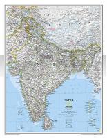
This new reference map is one of the most detailed ever published for India and southern Asia. It includes India, Sri Lanka, Nepal, Bangladesh, Bhutan, Tajikistan, and portions of China, Pakistan, Afghanistan, and Myanmar. The India map is punctuated with thousands of place names, and embellished with shaded relief to highlight the region`s dramatic topography in such places as the Tibetan Plateau and the Himalaya.

Indien PLANO-Karte 1:5.545 Mio. (Format: 60 x 77 cm) - gerollt im Plastikrohr
India flat map National Geographic
EAN / ISBN: 9781597750660
Preis: EUR 21.90

Bestellartikel: versandfertig in ca. 3-7 Tagen. Dieser Artikel wird speziell für Sie bestellt. Keine Rücknahme!
Produkt EUR Anzahl Bestellen
Indien PLANO-Karte 1:5.545 Mio. (Format: 60 x 77 cm) - gerollt im Plastikrohr
India flat map National Geographic
21.90
Versandkostenfrei in Deutschland ab 30,- Bestellwert

incl. MwSt.

Stichworte, die bei der Suche nützlich sein könnten:
Indien Wandkarte - Indien Planokarte - Indien - National Geographic - National Geographic Landkarten - Wandkarten - Posterkarten - Landkartenposter - Wandkarten - wall maps

Zuletzt angesehene Artikel:

CoverIndien PLANO-Karte 1:5.545 Mio. (Format: 60 x 77 cm) - gerollt im Plastikrohr
India flat map National Geographic

Cover2149 Usedom Amtliche Topographische Karte 1:25.000 Landesvermessungsamt Mecklenburg-Vorpommern

CoverBack to Cochem 1:25.000 Touristische Landkarte und Wanderkarte, Radwanderkarte - Mini Ardenne

Cover23 Bad Freienwalde und Umgebung GPS - mit Wanderwegen Topographische Freizeitkarte 1:25.000 Landesvermessung und Geobasisinformation Brandenburg

Noch kein Cover vorhandenL-34-15-C Budapest Süd Amtliche Topographische Karte Ungarn 1:50.000

CoverNiederrhein Nord - Reichswald - Gocher Heide 1:50.000 (Blatt 752) - Wanderkarte mit Broschüre KOMPASS

Cover03 Carta della Valchiusella - Alpi Canavesane - 1:20.000 Wanderkarte MU Edizioni - Italien

Cover67 Langisjor Topographische Karte Island 1:100.000 - Ferdakort
67 LANGISJÓR - Atlaskort - Ferðakort

Noch kein Cover vorhanden40 NN 1:25.000 (wasserfest) Topographische Wanderkarte und Straßenkarte 1:25.000 Fraternali Editore - Italien

CoverHajnowka - Powiat Hajnowski 1:10.000 Stadtplan
HAJNÓWKA - Powiat Hajnowski Agencja TD - Polen

CoverROUTE CARACREMADA Wanderkarte - Bergwanderkarte 1:50.000 - Editorial Piolet - Spanien
RUTA CARACREMADA EN BTT - A Cavall i Caracremeitor

CoverPolen - Administrative Karte 1:700.000
Rzeczpospolita Polska - Mapa administracyjna Polski Centrum Kartografii - Polen

Cover3000 Ibones - Balaitous - Infiernos - Gran Facha - Vignemale - Garmo Negro 1:25.000 Wanderkarte Spanien - ALPINA

Cover3123 Walsrode Amtliche topographische Karte 1:25.000 Landesvermessungsamt Niedersachsen

Noch kein Cover vorhanden208 S Nordkapp SØR 1:50.000 - Amtliche Topographische Landkarte Norwegen - Startens Kartverk

CoverMount Elgon - Wanderkarte und Wanderführer (engl.) Mount Elgon - Massaba (Kenya Uganda) map and guide 1:50.000 1:125.000 WEST COL PRODUCTIONS

CoverFontana - Hiwassee Lakes - Trail Map - North Carolina (Blatt: 784) Landkarte Trails Illustrated Map National Geographic - USA

CoverPistes du Maroc - Le Jebel Siroua et le pays Ouaouzguit Guide J. Gandini - Serre Editeur

Cover2211-I Sønderborg Topographische Karte Dänemark 1:50.000 - Kort & Matrikelstyrelsen ProjektNord

CoverTessin (Nr. 5929) - Wanderführer Wanderführer mit Extra-Tourenkarte, 50 Touren, GPX-Daten zum Download. - von Peter Mertz - KOMPASS