Willkommen bei MapFox
+++ Buchhändleranfragen willkommen! Tel. 0431-666 75 99 +++
Warenkorb
Artikel: 0 - € 0.00
Zur Kasse
Impressum Kontakt Versandkosten AGB
Djebel Akakus 1:100.000 Libyen WEST COL PRODUCTIONS
<< Libyen
<< EWP West Col Productions
 
Cover

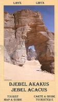
This is one of the more fascinating and beautiful areas of Libya. The mountains of Jebel Acacus cover a vast area of Fezzan east of Ghat. They contain some of the world`s best examples of cave art, some dating back 12,000 years. The scenes depict hunting, festivities, wild and domesticated animals and love making.

The main map is a scale of 1:100 000 while on the reverse is a map of the Northern Acacus at a scale of 1:400 000 - the tourist
guide has information on access the Tuaregs, cave art and walking routes; an essential piece of kit for anyone thinking of visiting
the Libyan desserts and mountains.

Kartenausschnitt

Kartenbeispiel

Djebel Akakus 1:100.000 Libyen WEST COL PRODUCTIONS
EAN / ISBN: 9780906227930
Preis: EUR 16.90

Bestellartikel: versandfertig in ca. 1-3 Wochen. Dieser Artikel wird speziell für Sie bestellt. Keine Rücknahme!
Produkt EUR Anzahl Bestellen
Djebel Akakus 1:100.000 Libyen WEST COL PRODUCTIONS 16.90
Versandkostenfrei in Deutschland ab 20,- Bestellwert

incl. MwSt.

Stichworte, die bei der Suche nützlich sein könnten:
Lybien Wanderkarte - West Col - EWP Akakus - Libyen - Libya - Libyen Landkarten - Libyen Straßenkarten - Libyen Autokarten - Libya road map - EWP - West Col Productions - Marokko Wanderkarten - Marokko Wanderführer - Asien - Kirgisien - Kirgistan - Afrika Wanderkarten - Uganda - Elbrus - Rwenzori - Tian Schan - Pamir - Atlas-Gebirge - Atlasgebirge - Kaukasus - Kamtschatka - Altai

Zuletzt angesehene Artikel:

CoverDjebel Akakus 1:100.000 Libyen WEST COL PRODUCTIONS

CoverSt. Catharines - Welland - Niagara Falls Street Map 1:31.250 Stadtplan Kanada GM Johnsons

CoverÖstliches Balkangebirge 1: Sliwen - E3 Bergwanderweg Kom-Emine - Topographische Wanderkarte 1:50.000 Bulgarien Landkarte ProjektNord

Cover6114 Wörrstadt - Wanderkarte mit Wanderwegen (geplottete Ausgabe) ProjektNord - Grundlage Amtliche topographische Karte Landesamt für Vermessung und Geobasisinformation Rheinland-Pfalz

Noch kein Cover vorhanden3032-SO Wustrow Topographische Karte 1:10.000 Niedersachsen ProjektNord

Cover2441 Grabowhöfe Amtliche Topographische Karte 1:25.000 Landesvermessungsamt Mecklenburg-Vorpommern

CoverNatur- und Geopark Vulkaneifel (NVE) mit Vulkaneifel-Pfaden - Topographische Wanderkarte u. Radwanderkarte 1:50.000 - Landesamt für Vermessung und Geobasisinformation Rheinland-Pfalz

CoverWzgorza Dalkowskie Touristenkarte 1:75.000
WZGÓRZA DALKOWSKIE PLAN Galileos - Polen

CoverBoundary Waters - W Superior - Minnesota (Blatt: 753) Landkarte Trails Illustrated Map National Geographic - USA

CoverDurban & surrounds visitor`s guide - with maps MapStudio Südafrika

Noch kein Cover vorhandenYakima / Yakima County Stadtplan 1:32.000 (Washington - USA)
Yakima / Yakima County street map GM Johnson

CoverWandertrilogie Allgäu - Wiesengänger Leporello Wanderkarte mit Ausflugszielen, Einkehr- & Freizeittipps, wetterfest, reißfest, abwischbar, GPS-genau. 1:35000 - von - Freytag-Berndt und ARTARIA PUBLICPRESS

CoverThe Kimberley Western Australia Regionalkarte 1:1.000.000 Regional Map / HEMA Maps
The Kimberley - featuring the Gibb River Road

CoverRepublik Weißrussland (kyrillisch) Straßenkarte 1:850.000
Respublika Belarus Kartografija - ukrmap Ukraine

CoverDonau-Radweg 2 - Passau - Wien Leporello Radtourenkarte mit Ausflugszielen, Einkehr- & Freizeittipps, wetterfest, reissfest, abwischbar, GPS-genau. 1:50000 - PUBLICPRESS

CoverL8522 Kressbronn am Bodensee (geplottete Ausgabe) Topographische Karte Bayern 1:50.000 Bayerisches Landesvermessungsamt

Noch kein Cover vorhanden3735 Wolmirstedt Topographische Karte 1:25.000 Landesamt für Vermessung und Geoinformation Sachsen-Anhalt (Landesvermessungsamt)

CoverL1344 Wiek Amtliche Topographische Karte 1:50.000 Landesvermessungsamt Mecklenburg-Vorpommern

CoverNaturpark Südeifel Blatt 1 Arzfeld (Nord) (S1) Topographische Wanderkarte 1:25.000 - Landesamt für Vermessung und Geobasisinformation Rheinland-Pfalz

CoverGroßer Ahlertsberg Topographische Wanderkarte mit Wanderwegen 1:25.000 - ProjektNord