Willkommen bei MapFox
+++ Buchhändleranfragen willkommen! Tel. 0431-666 75 99 +++
Warenkorb
Artikel: 0 - € 0.00
Zur Kasse
Impressum Kontakt Versandkosten AGB
South Dakota Recreation Map 1:633.600 - Landkarte Benchmark Map USA
<< USA: Wanderkarten, Nationalpark-Karten
<< Benchmark
 
Cover

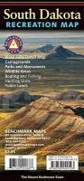
The South Dakota Recreation Map is the first map product to show the real richness of recreation potential in The Mount Rushmore State. One side provides a full state map that features Public & Tribal Lands, extensive highway detail, point-to-point mileages, recreation attractions, campgrounds, parks and wildlife areas, fishing access points, and hunting units (GMU). The reverse side features an area map of the Black Hills, and includes categorized recreation listings with helpful descriptions, current contact information, and map grid references.

Kartenausschnitt

Kartenbeispiel

South Dakota Recreation Map 1:633.600 - Landkarte Benchmark Map USA
EAN / ISBN: 9780783499123
Preis: EUR 11.90

Bestellartikel: versandfertig in ca. 1-3 Wochen. Dieser Artikel wird speziell für Sie bestellt. Keine Rücknahme!
Produkt EUR Anzahl Bestellen
South Dakota Recreation Map 1:633.600 - Landkarte Benchmark Map USA 11.90
Versandkostenfrei in Deutschland ab 20,- Bestellwert

incl. MwSt.

Stichworte, die bei der Suche nützlich sein könnten:
Aberdeen - Huron - South Dakota - Mitchell - Rapid City - South Dakota Landkarte - Pierre - Watertown - USA Wanderkarten - USA Landkarten - USA Nationalparks - USA National Parks - USA maps - Vereinigte Staaten Landkarten - USA Nationalpark-Karten - Benchmark - Benchmark Recreation maps - Benchmark Road Maps - Benchmark Roadatlases - Benchmark Atlanten - USA Atlanten - USA Recreation Atlases - Bundesstaatenkarten USA - Amerikanische Bundesstaaten - Vereinigte Staaten von Amerika Landkarte - US maps - US states maps

Zuletzt angesehene Artikel:

CoverSouth Dakota Recreation Map 1:633.600 - Landkarte Benchmark Map USA

Cover1156 SCHESAPLANA 1:25.000 - Falknis - Jenins - Fanas - Topographische Landeskarte der Schweiz - swisstopo

CoverAlberta 1:1 Mio. Touristische Landkarte
Easy to read provincial map GM Johnson

Cover69 Hjörleifshöfdi Topographische Karte Island 1:100.000 - Ferdakort
69 HJÖRLEIFSHÖFÐI - Atlaskort - Ferðakort

CoverMoselsteig - PremiumSet - Offizieller Wanderführer mit drei Karten 1:25.000 - GPS-Daten - Höhenprofile - Online-Anbindung - von Ulrike Poller und Wolfgang Todt - Idee-Media

CoverVom Ende einer Geschichte Roman. Ausgezeichnet mit dem Man Booker Prize 2011. Von Julian Barnes - Kiepenheuer & Witsch Verlag

CoverGuide découverte du Lot et Célé Guide Fluvial - Découverte de deux fleuves pittoresques: Le Lot et le Célé Wasserstraßen-Führer Frankreich - Édition du Breil

Cover31 Frutigland MTB-Karte 1:50.000 - Swiss Singletrail Map