| << Deutschland: Historische Karten und Stadtpläne (im Bereich der heutigen Bundesrepublik) << Rockstuhl |
||
|
||

Zuletzt angesehene Artikel:
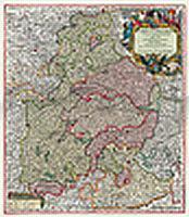
 | Bayern 1741 - Historische Landkarte Nachdruck Planokarte - gerollt von Seutter, Matthäus - Verlag Rockstuhl |
 | 44 Ankogel - Hochalmspitze - Wegmarkierung Wanderkarte Alpenvereinskarte Österreich 1:25.000 - Deutscher Alpenverein |
 | 136 S Sandnessjøen SØR 1:50.000 - Amtliche Topographische Landkarte Norwegen - Startens Kartverk |
 | 1143 LE LOCLE 1:25.000 - Morteau - Saut du Doubs - Le Col-des-Roches - Topographische Landeskarte der Schweiz - swisstopo |
 | Kuba - Antillen 1:1.25 Mio CUBA - ANTILLES - Internationale Landkarte - Cartographia |
 | 3717ETR Barr - Le Howald - Villé - Hte Vallée de la Bruche - Topographische Wanderkarte Frankreich 1:25.000 (LAMINIERTE AUSGABE) TOP 25 IGN - (GPS) |
 | ALABAMA Bundesstaatenkarte USA - Universal Map |
 | Stefan Loose Travel Handbücher Schottland von Eickhoff, Matthias |
 | Marokko Straßenkarte 1:1 Mio. (Blatt 742) Michelin |
 | L2326 Hamburg-Fuhlsbüttel Topographische Landkarte 1:50.000 Landesvermessungsamt Schleswig-Holstein |
 | Ratzeburger See Topographische Wanderkarte mit Wanderwegen und Radwegen 1:25.000 Schleswig-Holstein - ProjektNord |
 | 44 Königstein - Bad Gottleuba-Berggießhübel Topografische Karte 1:25.000 mit Wanderwegen - Landesvermessungsamt Sachsen - Wanderkarte |
 | 1310OT CHERBOURG-EN-COTENTIN - POINTE DE BARFLEUR - Topographische Wanderkarte Frankreich 1:25.000 TOP 25 IGN - (GPS) |
 | 1292 MAGGIA 1:25.000 Topographische Landeskarte der Schweiz - swisstopo |
 | 2435 Crivitz Amtliche Topographische Karte 1:25.000 Landesvermessungsamt Mecklenburg-Vorpommern |
| M-34-45-A/B Krasnik Amtliche topographische Landkarte Polen 1:50.000 M-34-45-A/B Krasnik - Mapa Topograficzna Polski Glowny Geodeta Kraju |
 | Irak 1:1.75 Mio. geografische Karte IRAQ GiziMap |
| M-33-33-A/B Legnica Amtliche topographische Landkarte Polen 1:50.000 M-33-33-A/B Legnica - Mapa Topograficzna Polski Glowny Geodeta Kraju |
 | Ustjordinsk Stadtplan 1:10.000 - Russland |